Airship Hangar No. 2 - interior to east end in 1994
Introduction
The photograph on this page of Airship Hangar No. 2 - interior to east end in 1994 by John Webb as part of the Geograph project.
The Geograph project started in 2005 with the aim of publishing, organising and preserving representative images for every square kilometre of Great Britain, Ireland and the Isle of Man.

There are currently over 7.5m images from over 14,400 individuals and you can help contribute to the project by visiting https://www.geograph.org.uk
Airship Hangar No. 2 - interior to east end in 1994
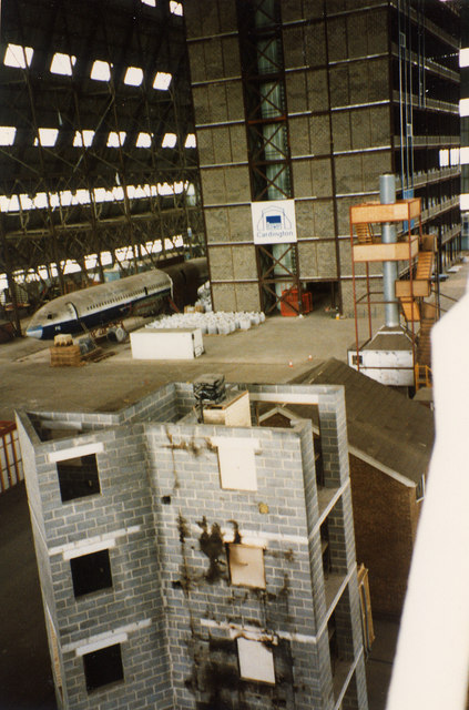
Image: © John Webb Taken: Unknown
Looking towards the east end of the hangar from the south central staircase at about 40 feet above the hangar floor. By this date the whole hangar was in the care of the Building Research Establishment, into which the Fire Research Station had been merged in 1972. Visible are in the foreground is a 5-storey tower used for investigating fire spread on external building cladding materials; behind and to the right is a gable wall and roof of a two-storey 3-bedroomed detached house, used for looking at problems of domestic fire detectors; mid-right of picture is a calorimeter hood used to measure the heat output of burning furniture and other items; rear centre is an eight-storey steel-framed office block built for fire and other structural tests, and to the left of that is a 707 fuselage used for work for CAA on improving fire resistance of aircraft seating. A view looking in the opposite direction is at Image (Photo is a scan of a print from a 35mm Agfa slide - see Image for a similar view in 1970.)
Images are licensed for reuse under creativecommons.org/licenses/by-sa/2.0
Image Location
Latitude
52.109041
Longitude
-0.421326