Linhay Hill Limestone Quarry - Ashburton
Introduction
The photograph on this page of Linhay Hill Limestone Quarry - Ashburton by Colin Vosper as part of the Geograph project.
The Geograph project started in 2005 with the aim of publishing, organising and preserving representative images for every square kilometre of Great Britain, Ireland and the Isle of Man.

There are currently over 7.5m images from over 14,400 individuals and you can help contribute to the project by visiting https://www.geograph.org.uk
Linhay Hill Limestone Quarry - Ashburton
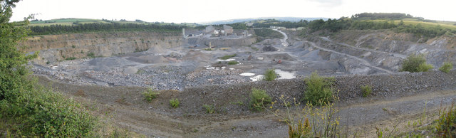
Image: © Colin Vosper Taken: 11 Jun 2011
On the south east edge of the quarry, just behind the hedge on the left of the photo, runs the very busy A38 Trunkroad. Most travelling along the road are unlikely to realise they are so close to this very large limestone quarry. This panoramic view is intended to show the full extent of the quarry on its eastern end. The width of the quarry shown in this view is around 400m (0.25 mile) across and is some 42m deep (145 feet). Image Many years ago the rock quarried from here was used by monumental masons as it could be worked to give a highly polished surface and was known as ‘Ashburton Marble’. Examples of such marble can be seen occasionally in churches and other buildings throughout Devon. Various local museums have examples too. For example, Dartmouth Museum has a fireplace on display with a marble surround which is believed to be of 'Ashburton Marble'. Image Torquay Museum has a sample of Ashburton Marble held in store. Image
Images are licensed for reuse under creativecommons.org/licenses/by-sa/2.0
Image Location
Latitude
50.528439
Longitude
-3.735594