Town Bridge plaque, Pontypool
Introduction
The photograph on this page of Town Bridge plaque, Pontypool by Jaggery as part of the Geograph project.
The Geograph project started in 2005 with the aim of publishing, organising and preserving representative images for every square kilometre of Great Britain, Ireland and the Isle of Man.

There are currently over 7.5m images from over 14,400 individuals and you can help contribute to the project by visiting https://www.geograph.org.uk
Town Bridge plaque, Pontypool
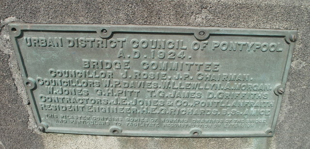
Image: © Jaggery Taken: 4 May 2011
The plaque on the bridge https://www.geograph.org.uk/photo/5846462 across the Afon Lwyd records the bridge's opening in 1924, and the names of the bridge committee. The bottom two lines record that the pilaster (on which the plaque is affixed) contains copies of working drawings of the bridge and particulars to facilitate reconstruction or extension. A differently-worded plaque https://www.geograph.org.uk/photo/5846445 is on the opposite side of the bridge.
Images are licensed for reuse under creativecommons.org/licenses/by-sa/2.0
Image Location
Latitude
51.703115
Longitude
-3.041847