The Muckamore Bridge (1)
Introduction
The photograph on this page of The Muckamore Bridge (1) by Albert Bridge as part of the Geograph project.
The Geograph project started in 2005 with the aim of publishing, organising and preserving representative images for every square kilometre of Great Britain, Ireland and the Isle of Man.

There are currently over 7.5m images from over 14,400 individuals and you can help contribute to the project by visiting https://www.geograph.org.uk
The Muckamore Bridge (1)
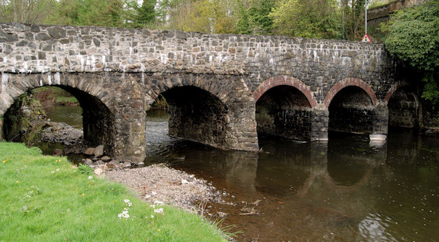
Image: © Albert Bridge Taken: 14 Apr 2011
The listed bridge (HB20/13/007) carries the Oldstone Road across the Sixmilewater. Thought to date from 1780/1799. The List includes this description “Built mainly of blackstone rubble with rough stone voussoirs to segmental arches, rubble vaults, and the piers faced with triangular cutwaters of similar rubble, but the northern arches on the upstream side have been rebuilt with brick voussoirs and vaults, and their piers faced with lower triangular cutwaters of coursed basalt. On the west face the spandrels and parapet are of basalt rubble, in the same plane, but the top of the parapet has been newly rebuilt.” The view is downstream. See also Image
Images are licensed for reuse under creativecommons.org/licenses/by-sa/2.0
Image Location
Latitude
54.704715
Longitude
-6.189604