Milepost on Ladderedge
Introduction
The photograph on this page of Milepost on Ladderedge by Jonathan Kington as part of the Geograph project.
The Geograph project started in 2005 with the aim of publishing, organising and preserving representative images for every square kilometre of Great Britain, Ireland and the Isle of Man.

There are currently over 7.5m images from over 14,400 individuals and you can help contribute to the project by visiting https://www.geograph.org.uk
Milepost on Ladderedge
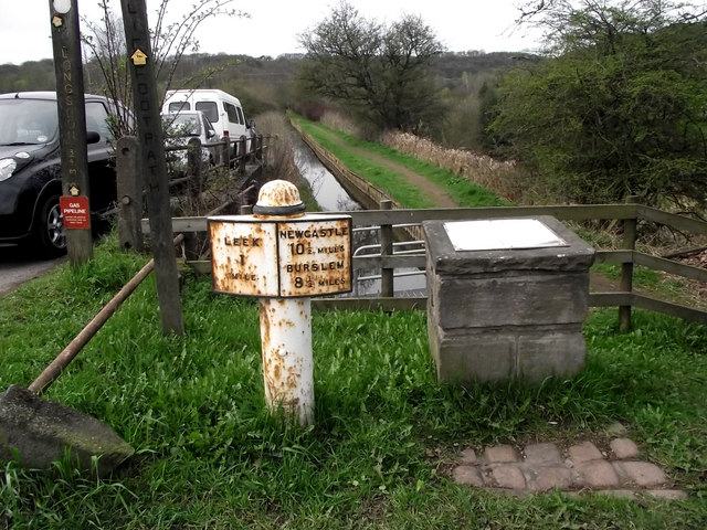
Image: © Jonathan Kington Taken: 6 Apr 2011
This Grade II Listed ( http://www.britishlistedbuildings.co.uk/en-461670-mile-post-at-ngr-sj-973-551-leek ) milepost is at the bottom of Ladderedge Bank on the A53 Newcastle Road out of Leek, the stone to the right gives information about local walks. Behind can be seen the Feeder Canal coming from Rudyard Lake to the Leek Branch of the Caldon Canal. Although milestones and mileposts have been around in Britain since the Romans started building roads here, it wasn’t until the Turnpike Act of 1766 that they became compulsory on the turnpike roads which were built under Government licence by private companies who used the money raised by tolls to maintain them. Prior to the Act milestones were only occasionally erected, usually as a charitable act to reassure travellers that they were on the right road or for commemorative reasons. There are still quite a few of the Turnpike Act milestones in existence, normally they are 2-3 feet high and have the initial letter or an abbreviation of the nearest market town marked on two faces with the distance from it.
Images are licensed for reuse under creativecommons.org/licenses/by-sa/2.0
Image Location
Latitude
53.09356
Longitude
-2.040666