Castle Hill
Introduction
The photograph on this page of Castle Hill by Lairich Rig as part of the Geograph project.
The Geograph project started in 2005 with the aim of publishing, organising and preserving representative images for every square kilometre of Great Britain, Ireland and the Isle of Man.

There are currently over 7.5m images from over 14,400 individuals and you can help contribute to the project by visiting https://www.geograph.org.uk
Castle Hill
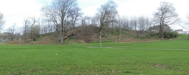
Image: © Lairich Rig Taken: 7 Apr 2011
This knoll, located at the north-eastern corner of the Image, has many rock outcrops on its sides. It used to be thought (mainly on account of its name) that the hill had been the residence of King Robert the Bruce in his later years. That traditional association is no longer in favour, but it does explain the presence of Image nearby. Castle Hill gives the Castlehill area of Dumbarton its name. I took another photograph from much the same spot, less than a month later; on that occasion the hill looked considerably less bleak: Image A similar knoll not far to the west is called Image; again, see Image The name Castle Hill is an old one: a charter made in 1542 grants to Archibald Campbell, master of the King's wine-cellar, the "terras de Kirktoun de Cardros, Dalmowok, Weltoun et molendinum earundem, terras de Castelhill, Hole, et Hawthornehill, vic. Dunbertane", etc.; that is, the lands of Kirkton of Cardross, Dalmoak, Walton, and their mill, the lands of Hole and Hawthornhill in the Shire (Sheriffdom) of Dumbarton [charter #2630 in RMS Vol. 2]. "Kirkton": near Image, the ancient Cardross Parish church, in what is now Levengrove Park. "Dalmoak", "Walton", "Hawthornhill": these names (all originally of farms; see Image) are still in use, and they can be found on the map. "Hole" (sometimes "Hoill"): for Easter or Foul Hole, sometimes called Hoill of Cardross, see Image; Wester Hole was near Ardoch, and was sometimes called Hoill of Ardoch.
Images are licensed for reuse under creativecommons.org/licenses/by-sa/2.0
Image Location
Latitude
55.948731
Longitude
-4.587882