
Princesses Parade on the Waterside , Crayford
Introduction
The photograph on this page of Princesses Parade on the Waterside , Crayford by Roger D Kidd as part of the Geograph project.
The Geograph project started in 2005 with the aim of publishing, organising and preserving representative images for every square kilometre of Great Britain, Ireland and the Isle of Man.

There are currently over 7.5m images from over 14,400 individuals and you can help contribute to the project by visiting https://www.geograph.org.uk
Princesses Parade on the Waterside , Crayford
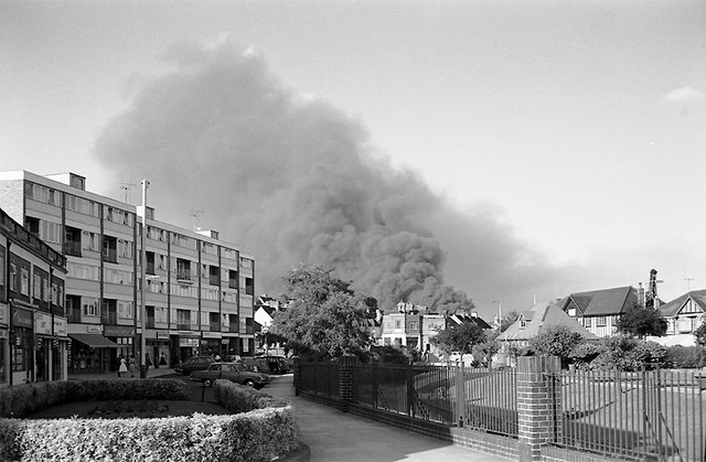
Image: © Roger D Kidd Taken: 13 Jul 1964
Looking towards Crayford Way, the B2186. When I took this photograph this was in Kent, and I still see it that way! Although the fire appears to be behind the houses, it was more than half a mile away. The River Cray flows by the fence, through the gardens on the right. For comparison, and details regarding the shops and flats, built in 1916, please do look at Nigel Cox's 2008 image Image Having helped me find out where I was to get this July 1964 image, Nigel has also unearthed this fascinating information: "Fire brigades from Dartford, Bexley and Sidcup were called yesterday to fight a fire at an oil and rosin refinery at Jolly Farmers Wharf, Crayford in Kent. At one time 50 firemen were engaged, but later more men and machines were called for until there were 80 men and 15 appliances in action. Oil drums exploded on the wharf as flames spread. Trains using the railway line alongside the depot were slowed down. Some traffic was diverted and extra police called in to control the crowds. The fire was later brought under control. A fire brigade official said that damping down operations would go on all night." (from "The Times" 14 July 1964). The hedged garden area in the foreground has now gone. Image scanned from a 35mm Ilford FP3 monochrome negative.
Images are licensed for reuse under creativecommons.org/licenses/by-sa/2.0
Image Location

Latitude
51.452448
Longitude
0.179091