Seaton Station and Welland Viaduct, c.1967
Introduction
The photograph on this page of Seaton Station and Welland Viaduct, c.1967 by John Brightley collection as part of the Geograph project.
The Geograph project started in 2005 with the aim of publishing, organising and preserving representative images for every square kilometre of Great Britain, Ireland and the Isle of Man.

There are currently over 7.5m images from over 14,400 individuals and you can help contribute to the project by visiting https://www.geograph.org.uk
Seaton Station and Welland Viaduct, c.1967
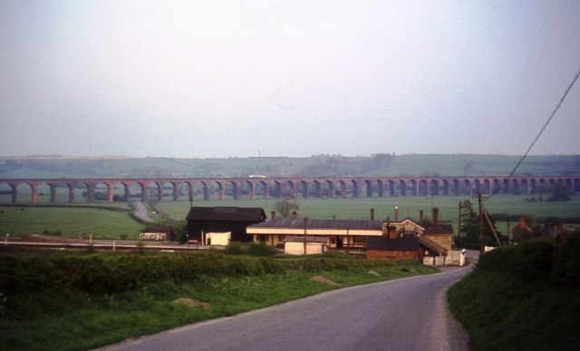
Image: © John Brightley collection Taken: Unknown
The photo shows Seaton Station which was at the junction of the LNWR line from Rugby to Peterborough and the branch to Stamford. The station closed in 1966, but it looks completely intact in this view, except for the fact that a couple of the level crossing gates seem to be lying discarded by the buildings on the left. This leads me to think that the photo was taken shortly after closure, which would fit in well with information on other photos in the same set. If you can date the photo more accurately please let me know. The Welland (or Harringworth) Viaduct (carrying the Midland railway line) can be seen in the background.
Images are licensed for reuse under creativecommons.org/licenses/by-sa/2.0
Image Location


Leaflet Map data © OpenStreetMap
Latitude
52.571341
Longitude
-0.660496