Dean Lane Overbridge
Introduction
The photograph on this page of Dean Lane Overbridge by Ian Capper as part of the Geograph project.
The Geograph project started in 2005 with the aim of publishing, organising and preserving representative images for every square kilometre of Great Britain, Ireland and the Isle of Man.

There are currently over 7.5m images from over 14,400 individuals and you can help contribute to the project by visiting https://www.geograph.org.uk
Dean Lane Overbridge
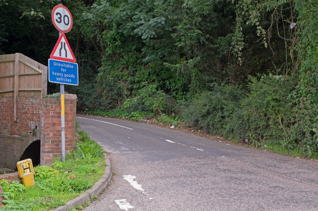
Image: © Ian Capper Taken: 18 Sep 2010
The parapet and arch on the left of the photo are one of the few physical remnants of the Croydon, Merstham and Godstone Iron Railway, opened in 1805 as a southern extension of the 1803 Surrey Iron Railway, the first public railway in the world. The purpose of the CM&GIR was to carry chalk and stone from Merstham Quarry, using horse drawn trucks. It was originally intended to continue to Godstone Green (hence Godstone in the name) and also Reigate, but these extensions never happened. The parapet and top of the arch are the remains of the bridge where Dean Lane crossed the railway, next to the lane's junction with the A23 Brighton Road. The southern parapet, on the right hand side of the road, was demolished by Canadian troops during the Second World War, who used Dean Lane to gain access to their camp on Alderstead Heath (see Image). The bridge has been scheduled as an Ancient Monument and is locally listed. For a closer view of the archway and parapet, see Image
Images are licensed for reuse under creativecommons.org/licenses/by-sa/2.0
Image Location
Latitude
51.286953
Longitude
-0.155017