The site of St William's chapel in Mousehold Heath
Introduction
The photograph on this page of The site of St William's chapel in Mousehold Heath by Evelyn Simak as part of the Geograph project.
The Geograph project started in 2005 with the aim of publishing, organising and preserving representative images for every square kilometre of Great Britain, Ireland and the Isle of Man.

There are currently over 7.5m images from over 14,400 individuals and you can help contribute to the project by visiting https://www.geograph.org.uk
The site of St William's chapel in Mousehold Heath
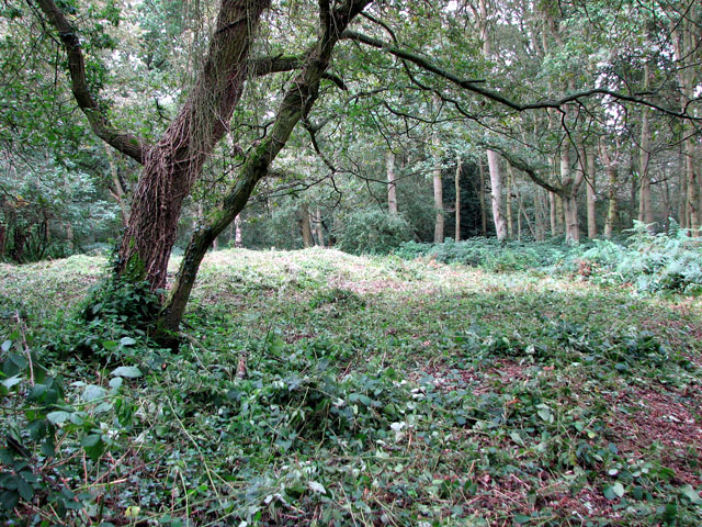
Image: © Evelyn Simak Taken: 11 Sep 2010
In 1144 the body of a boy - William, a tanner's apprentice from Norwich - was found on at this spot in Mousehold Heath. His death was believed to have been the result of ritual murder carried out by Jews. He attained the status of saint and martyr, and after initially having been buried where he was found, his body was exhumed and enshrined in 1150 in the Norwich (now Anglican) Cathedral. A chapel that already stood here - belonging to the priory that once stood here and dedicated to St Catherine de Monte - was to be re-consecrated to the honour of William. Until this day the site is being kept clear of bracken and brambles and it can easily be found. It is situated beside a footpath leading through the heath, a short distance to the south-west of the junction of Gurney Road and Heartsease Lane > http://www.geograph.org.uk/photo/2061537. One of the rood screen panels > http://www.geograph.org.uk/photo/5449679 in Holy Trinity church at Loddon, South Norfolk, depicts the scene of the martyrdom of St William of Norwich, as he became known. Mousehold Heath once formed part of the great expanse of heathland that extended from the north-eastern bank of the River Wensum towards the villages of Salhouse and Rackheath. Originally the heath was maintained by grazing but without maintenance the trees have grown tall and the area is now a woodland much frequented by walkers. The overgrown workings of 19th century gravel, flint, lime and marl extraction can still be seen. Mousehold Heath covers nearly 200 acres (81 ha) and is much appreciated by Norwich people as a public open space.
Images are licensed for reuse under creativecommons.org/licenses/by-sa/2.0
Image Location
Latitude
52.645297
Longitude
1.320462