Earthquake House
Introduction
The photograph on this page of Earthquake House by Anne Burgess as part of the Geograph project.
The Geograph project started in 2005 with the aim of publishing, organising and preserving representative images for every square kilometre of Great Britain, Ireland and the Isle of Man.

There are currently over 7.5m images from over 14,400 individuals and you can help contribute to the project by visiting https://www.geograph.org.uk
Earthquake House
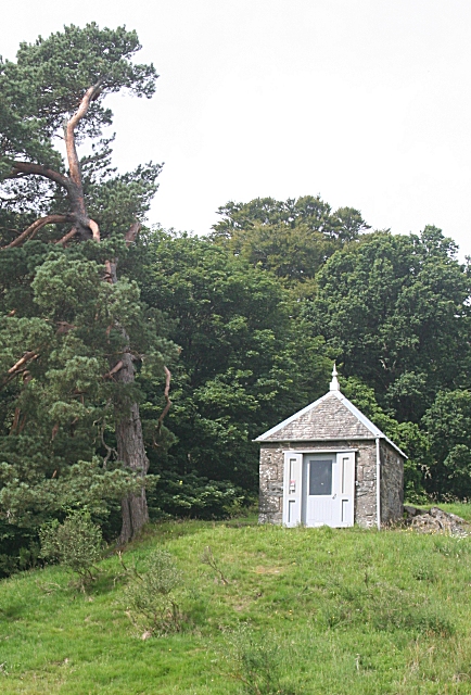
Image: © Anne Burgess Taken: 27 Jul 2010
Comrie stands close to the Highland Boundary Fault (HBF), a major geological feature in Scotland which separates the Highlands from the Central Lowlands or Midland Valley, and has long been famed as Scotland's earthquake capital. Interestingly, the interactive map of UK earthquakes on the BGS Website http://www.earthquakes.bgs.ac.uk/ does not imply that Comrie is an earthquake hotspot at all! The fact that the earthquakes are localised, rather than occurring with equal frequency right along the fault, suggests that they are not necessarily due to the HBF, and may be related to some other geological structure or feature not now visible on the ground. Interested people have been collecting information about the Comrie earthquakes since the latter half of the 18th century, information which is still useful for geological research in the 21st century. The 1840s saw the development of the seismoscope, an instrument which registered earthquakes. This was superseded by more sophisticated instruments capable of recording not just the occurrence and strength of an earthquake, but also the time, the exact location of its epicentre (the point on the surface of the Earth directly above the focus, which is the point in the Earth's crust at which displacement has occurred) and its depth in the crust. Earthquake House stands on a knoll in a field in the Ross, one of the three old settlements which make up the village of Comrie, the others being the village itself and Dalginross. It was built in 1874 and equipped with a seismoscope, but earthquake activity declined and it was never used. The building was neglected until 1986, when it was restored. It contains a model of the original instrument and a modern seismograph installed by the British Geological Survey.
Images are licensed for reuse under creativecommons.org/licenses/by-sa/2.0
Image Location
Latitude
56.371794
Longitude
-4.000472