Milnquarter: Roman construction camp
Introduction
The photograph on this page of Milnquarter: Roman construction camp by Lairich Rig as part of the Geograph project.
The Geograph project started in 2005 with the aim of publishing, organising and preserving representative images for every square kilometre of Great Britain, Ireland and the Isle of Man.

There are currently over 7.5m images from over 14,400 individuals and you can help contribute to the project by visiting https://www.geograph.org.uk
Milnquarter: Roman construction camp
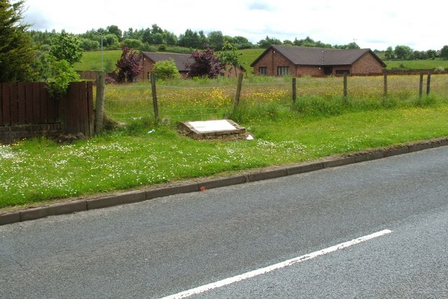
Image: © Lairich Rig Taken: 14 Jun 2010
The outline of this camp, which was first noticed on aerial photographs, is marked on the 1:25000 OS map. It was a temporary camp, one of several that are situated close to the line of the Antonine Wall (for nearby sites on the wall, see, for example, Image, Image, and Image). An information panel beside Reilly Road (both the road and the panel are visible in the foreground of this photograph) gives an account of the Wall itself, and then goes on to discuss the associated construction camps, of which the camp at Milnquarter is thought to be an example; it notes that these camps are "usually sited within 500m of the Wall, and are much smaller in size than normal Roman temporary marching camps. Therefore they are assumed to relate to the Wall and to have housed troops working on the wall and its constituent forts, fortlets, and road network". In 2009, the area covered by this camp was given legal protection as a scheduled monument, except for those parts that had already been built upon (for example, Image and the nearby railway line both pass through the camp). As noted above, the 1:25000 map shows its outline; see also the following satellite view, which has been annotated to show the camp's approximate boundaries: https://www.google.com/maps/d/viewer?mid=1Gb6jqR4Ymy2mnN0ljVcRsYmbpts&ll=55.99276251261296%2C-3.8842699999999013&z=18 The eastern corner of the camp, as shown on that satellite view, corresponds to the clearing that is shown enclosed by a fence in this photograph. Likewise, the western corner of the camp corresponds to a square area of land, just west of the railway line, that has been kept clear of buildings.
Images are licensed for reuse under creativecommons.org/licenses/by-sa/2.0
Image Location
Latitude
55.992801
Longitude
-3.882719