Brackley Town Station (remains)
Introduction
The photograph on this page of Brackley Town Station (remains) by Ben Brooksbank as part of the Geograph project.
The Geograph project started in 2005 with the aim of publishing, organising and preserving representative images for every square kilometre of Great Britain, Ireland and the Isle of Man.

There are currently over 7.5m images from over 14,400 individuals and you can help contribute to the project by visiting https://www.geograph.org.uk
Brackley Town Station (remains)
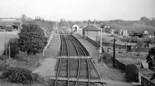
Image: © Ben Brooksbank Taken: 24 Mar 1961
View eastward, towards Buckingham, Verney Junction and Bletchley; ex-LNW Bletchley - Banbury line. The station was closed to passengers on 2/1/61 - less than three months before this photograph, in spite of an early experiment from 1956 with a single-unit Diesel railcar running between Buckingham and Banbury and calling also at two new Halts, which proved to be a success. The service was then cut back to Bletchley - Buckingham only (with the railcar) until 7/9/64. (Goods traffic on the branch ceased completely west of Buckingham on 2/12/63, from Bletchley on 5/12/66).
Images are licensed for reuse under creativecommons.org/licenses/by-sa/2.0
Image Location
Latitude
52.023661
Longitude
-1.148837