286 and 288 Leigham Court Road
Introduction
The photograph on this page of 286 and 288 Leigham Court Road by Stephen Richards as part of the Geograph project.
The Geograph project started in 2005 with the aim of publishing, organising and preserving representative images for every square kilometre of Great Britain, Ireland and the Isle of Man.

There are currently over 7.5m images from over 14,400 individuals and you can help contribute to the project by visiting https://www.geograph.org.uk
286 and 288 Leigham Court Road
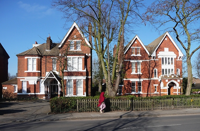
Image: © Stephen Richards Taken: Unknown
Two of a group of five large Victorian houses at the south end of the road. The one on the right has an elaborate castellated porch and a large staircase window. They are within the Leigham Court Road (South) Conservation Area. Leigham Court Road was laid out in 1839, and while development began in the early 1840s, it didn’t really take off until after the building of the Crystal Palace and West End Railway and the opening of Streatham Hill station in 1856. Quite a number of the original, large Victorian houses survive at either end of the road, and even though their grounds have in some cases since been built on, the remaining mature trees and general landscaping have enabled the area to retain “much of its original arcadian character.” Information from Lambeth Council (http://www.lambeth.gov.uk/NR/exeres/CE4B5CE1-0387-40ED-B5A9-273A5160C34A.htm )
Images are licensed for reuse under creativecommons.org/licenses/by-sa/2.0
Image Location
Latitude
51.425532
Longitude
-0.114444