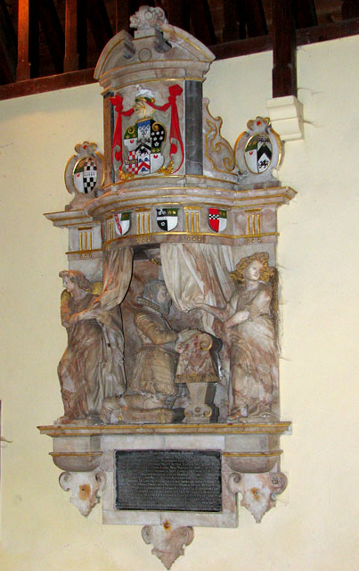
St Peter's church - memorial to Drue Drury (d 1617)
Introduction
The photograph on this page of St Peter's church - memorial to Drue Drury (d 1617) by Evelyn Simak as part of the Geograph project.
The Geograph project started in 2005 with the aim of publishing, organising and preserving representative images for every square kilometre of Great Britain, Ireland and the Isle of Man.
There are currently over 7.5m images from over 14,400 individuals and you can help contribute to the project by visiting https://www.geograph.org.uk

Image: © Evelyn Simak Taken: 13 Feb 2010
The building > http://www.geograph.org.uk/photo/1707334 dates from the 14th century but the chancel was rebuilt in 1855. The C14 octagonal font > http://www.geograph.org.uk/photo/1707358 has survived, its cover is Jacobean. The royal arms for Charles I > http://www.geograph.org.uk/photo/1707361 - overpainted for Charles II - came from the ruined Knettishall church which also provided the Jacobean pulpit > http://www.geograph.org.uk/photo/1707339. The church houses a number of memorials, the most noteworthy of them to Sir Drue Drury > http://www.geograph.org.uk/photo/1707353 who died in 1617 at the age of 99. He was Governor of the Tower of London and had guarded Mary Queen of Scots before her execution in 1587. The church is adjoined by Riddlesworth Hall > http://www.geograph.org.uk/photo/1707322. The village of Riddlesworth is mentioned in Alan Davison's book 'Deserted Villages in Norfolk' as having been a small and moderately prosperous place in the 1340s. By 1584 it was tiny, consisting of manor house, church, rectory and 10 houses, and in the 1670s its size had dwindled to two houses and 15 people. Whether as a result of depopulation by the Drurys, the Lords of the Manor, is not known. The modern-day hamlet consists of Manor Farm, a handful of cottages and St Peter's church. The Hall, and attractive Georgian-style house surrounded by 30 acres of parkland, now functions as a school.

