
Middleton from the air
Introduction
The photograph on this page of Middleton from the air by Ian Taylor as part of the Geograph project.
The Geograph project started in 2005 with the aim of publishing, organising and preserving representative images for every square kilometre of Great Britain, Ireland and the Isle of Man.

There are currently over 7.5m images from over 14,400 individuals and you can help contribute to the project by visiting https://www.geograph.org.uk
Middleton from the air
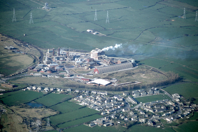
Image: © Ian Taylor Taken: Unknown
There are essentially 2 gridsquares in this view from Spring 1982: SD4258 in the foreground and SD4259 in the background. (Small parts of SD4158, SD4260 & SD4359 are also visible.) Middleton village is in the foreground, with Middleton Road crossing from left to right in front of the line of trees. Beyond that is the eastern part of the Trimpell industrial site. Most of this has since been demolished, but the storage silo in the centre of the photo still remains (see Image). The old railway sidings can be seen, forming a D at the left hand side of the photo. A new access road has now been built on this railway embankment, which links to the relatively new A683 Heysham bypass (seeImage). At the top of the photo are the pylons for Heysham power station, and the BT telecommunication tower (see Image).
Images are licensed for reuse under creativecommons.org/licenses/by-sa/2.0
Image Location

Latitude
54.022673
Longitude
-2.882815