Great Malvern Priory Lands
Introduction
The photograph on this page of Great Malvern Priory Lands by Bob Embleton as part of the Geograph project.
The Geograph project started in 2005 with the aim of publishing, organising and preserving representative images for every square kilometre of Great Britain, Ireland and the Isle of Man.

There are currently over 7.5m images from over 14,400 individuals and you can help contribute to the project by visiting https://www.geograph.org.uk
Great Malvern Priory Lands
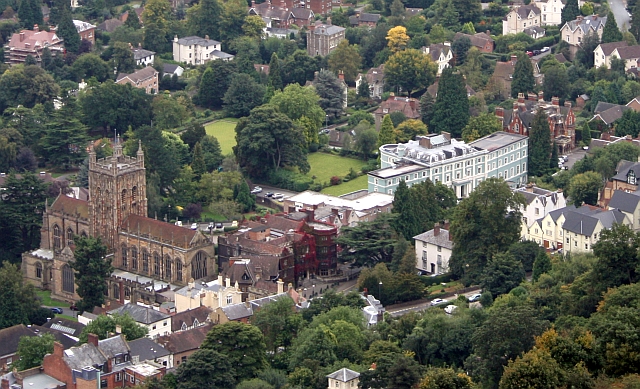
Image: © Bob Embleton Taken: 13 Sep 2009
The land of the priory has been developed since the reformation. Just to the right of the priory church is the misnamed Abbey Hotel covering whatever remains of the monastic buildings. Further to the right is the green and white building now called Parkview. This was built by Doctor Wilson in the 1840s as his "water cure" establishment. Later it became the County Hotel then after the war it became the lively Park View Hostel for apprentices and scientists at the radar research laboratories. It has now been converted into private apartments.
Images are licensed for reuse under creativecommons.org/licenses/by-sa/2.0
Image Location
Latitude
52.109169
Longitude
-2.328346