River Gade and the A4146 road bridge at Water End
Introduction
The photograph on this page of River Gade and the A4146 road bridge at Water End by Nigel Cox as part of the Geograph project.
The Geograph project started in 2005 with the aim of publishing, organising and preserving representative images for every square kilometre of Great Britain, Ireland and the Isle of Man.

There are currently over 7.5m images from over 14,400 individuals and you can help contribute to the project by visiting https://www.geograph.org.uk
River Gade and the A4146 road bridge at Water End
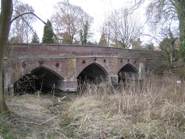
Image: © Nigel Cox Taken: 19 Mar 2006
Very similar in design to the other road bridge over the Gade in Water End, Image but about 500 metres upstream of it, this is the downstream face. The bridge is a Grade II Listed Structure and the Historic England website describes it thus:- "Circa 1800 when road realigned, restored and parapet raised 2 courses 1976 by Herts County Council. Red brick with random black headers in English-bond with stone string courses and copings to parapet. A long narrow bridge, slightly humped to centre, of 3 pointed arches, 4 brick cutwaters, and brick parapets splaying out at ends and terminating in octagonal brick piers. The bridge has not been widened and differs from the widened South Bridge (q.v.) in having brick cappings to the cutwaters and having its moulded stone string at road level extended along the abutment walls to the terminal piers. It also has 3 moulded circular cast iron tie-rod plates over each arch. There is a chamfered brick rib just within the mouth of each arch. A chamfered stone offset to the plinth provides the springing for the arches. Plinths linked by a weir near the upstream side where water level is just below this stone offset."
Images are licensed for reuse under creativecommons.org/licenses/by-sa/2.0
Image Location


Leaflet Map data © OpenStreetMap
Latitude
51.783581
Longitude
-0.499546