Glyn Bends construction
Introduction
The photograph on this page of Glyn Bends construction by Jonathan Wilkins as part of the Geograph project.
The Geograph project started in 2005 with the aim of publishing, organising and preserving representative images for every square kilometre of Great Britain, Ireland and the Isle of Man.

There are currently over 7.5m images from over 14,400 individuals and you can help contribute to the project by visiting https://www.geograph.org.uk
Glyn Bends construction
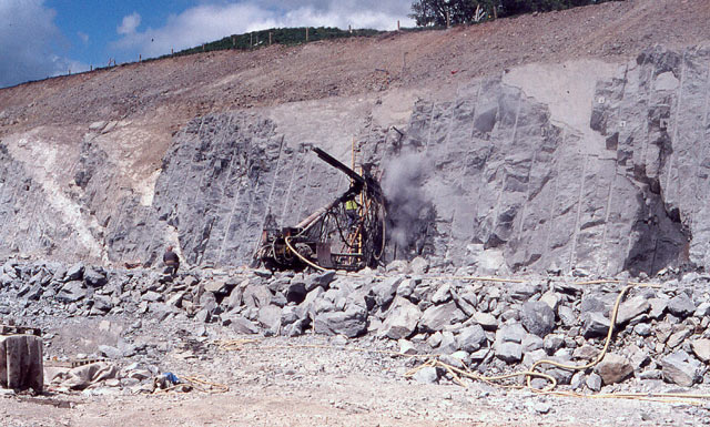
Image: © Jonathan Wilkins Taken: Unknown
The story of the A5 diversion at Ty Nant has a long history. In Eirian's image we see the failed cutting slope and a considerable landslip Image In Eric's image we see work on the total removal of the landslipped section Image, and the completed work and the re-profiled cutting in my own Image Here we go back to May 1995 and the original construction just to the south-east of the failed slope. The drilling rig is installing ground anchors to tie together the faulted blocks of Silurian mudstone. One of the anchors can be seen protruding from a freshly-drilled hole just above the rig. The flat, triangular areas on the rock face are the outcrops of the faults which ultimately overcame the ground anchors and slipped again. A classic tale of ingenuity overcome by the complexity of real ground conditions. The image was captured, with permission, during an excursion of the North Wales Geology Association.
Images are licensed for reuse under creativecommons.org/licenses/by-sa/2.0
Image Location
Latitude
52.987972
Longitude
-3.502144