Alexander Keiller's crash site (1), Marlborough
Introduction
The photograph on this page of Alexander Keiller's crash site (1), Marlborough by Brian Robert Marshall as part of the Geograph project.
The Geograph project started in 2005 with the aim of publishing, organising and preserving representative images for every square kilometre of Great Britain, Ireland and the Isle of Man.

There are currently over 7.5m images from over 14,400 individuals and you can help contribute to the project by visiting https://www.geograph.org.uk
Alexander Keiller's crash site (1), Marlborough
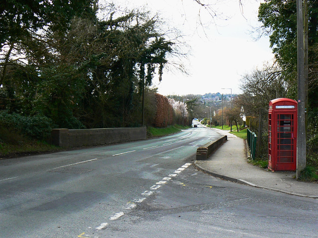
Image: © Brian Robert Marshall Taken: 28 Mar 2009
Alexander Keiller was a member of the Dundee Keiller family who made a fortune from the manufacture of marmalade. Alexander became well known in his own right for his involvement in the archaeology of Windmill Hill http://www.geograph.org.uk/photo/1010961 and Avebury http://www.geograph.org.uk/photo/885313 in the 1920s and 1930s. As well as a passion for digging things up Keiller was deeply interested in the recreational possibilities offered by women and fast cars. On 9th July 1929 he was driving with a Miss Duncan in his Targa Florio Bugatti along this stretch of the A4 towards the viewpoint. On that occasion he got no further. In his own words: "... The actual site of the crash you must know well. It is the Railway Bridge on the hill climbing into Savernake out of Marlborough on the main Bath Road. We were climbing this hill at a reasonable speed, but not by any manner of means, I consider, an excessive one, viz. some 84 miles an hour, when my back axle broke and, the car turning round and rising into the air, we hurtled ourselves onto the angular portion of the Bridge. It is fortunate that we hit the angle, since otherwise, considering the speed at which we were travelling, we must have burst through the brickwork and fallen another forty feet onto the Railway line below. It is of course miraculous that either of us lived through the experience." (Source: 'A Zest for Life - the story of Alexander Keiller', Lynda J Murray, Morven Books 1999). The speed limit on this part of the road is now 30 mph and the railway is now a cycle path. It is noticeable that the wall over the bridge on the right, which is the one Keiller must have hit, is much lower than its opposite number. Possibly it was never rebuilt to its original height after the collision. The other, more prosaic likelihood is that the height of the wall was reduced to improve the sight-line from the road joining the A4.
Images are licensed for reuse under creativecommons.org/licenses/by-sa/2.0
Image Location
Latitude
51.418583
Longitude
-1.712627