Southend ATC
Introduction
The photograph on this page of Southend ATC by Glyn Baker as part of the Geograph project.
The Geograph project started in 2005 with the aim of publishing, organising and preserving representative images for every square kilometre of Great Britain, Ireland and the Isle of Man.

There are currently over 7.5m images from over 14,400 individuals and you can help contribute to the project by visiting https://www.geograph.org.uk
Southend ATC
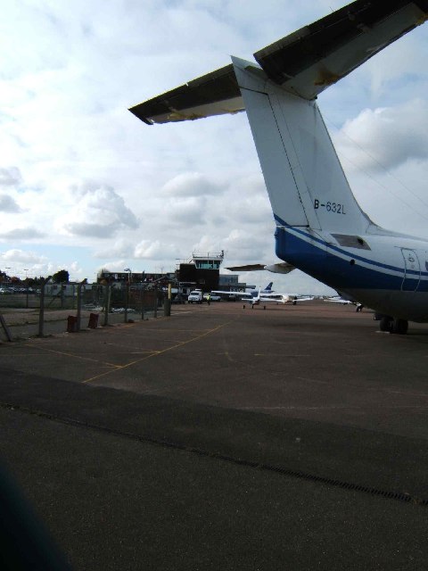
Image: © Glyn Baker Taken: 10 Feb 2006
This is the Air Traffic Control building and the apron at “London” Southend Airport framed under the tail of a rather bedraggled BAE146 that has been waiting for a buyer since at least 2003. You can get some better views of the aircraft at http://abpic.co.uk/pictures/registration/B-632L . Southend Airport began life as a fighter field in WW1 to counter the bomber raids that were occurring in the latter end of the war. The airfield closed in the 1920’s but became the Southend’s municipal airport in the 1930’s. It was requisitioned in 1939 as RAF Rochford a satellite of RAF Hornchurch. Civilian flying began again in 1947. In the 1960s Carvair air car ferries operated from here http://aviationtraderscarvair.com/ famously carrying James Bond's Aston Martin to Switzerland in “Goldfinger”. To go to the next field in an alphabetical tour of Essex WW2 airfields click on Image Much information was gleaned from Graham Smith’s book “Essex Airfields In The Second World War”. https://books.google.co.uk/books/about/Essex_Airfields_in_the_Second_World_War.html?id=u3atAAAACAAJ&redir_esc=y
Images are licensed for reuse under creativecommons.org/licenses/by-sa/2.0
Image Location
Latitude
51.567859
Longitude
0.70112