St Giles Parish Church
Introduction
The photograph on this page of St Giles Parish Church by Alan Murray-Rust as part of the Geograph project.
The Geograph project started in 2005 with the aim of publishing, organising and preserving representative images for every square kilometre of Great Britain, Ireland and the Isle of Man.

There are currently over 7.5m images from over 14,400 individuals and you can help contribute to the project by visiting https://www.geograph.org.uk
St Giles Parish Church
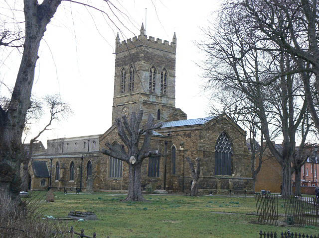
Image: © Alan Murray-Rust Taken: 26 Feb 2009
Despite its size and location close to the town centre, this is not in fact the 'town' church of Northampton, which is All Hallows, right in the traditional centre. The Romanesque Sculpture in Britain and Ireland website http://www.crsbi.ac.uk/index.html contains the following general description of the church, which dates from the 12 century but has had several significant periods of rebuilding. "The church of St Giles is a large cruciform building with a crossing tower. The tower is 12thc. in its lower parts and has crossing arches to E and W only. To the N and S are plain walls now; the arches were blocked after the upper part of the tower collapsed in 1613. Rebuilding was from 1616, and included the E bays of the N nave arcade and the clerestorey as well as the tower. The aisled and clerestoreyed nave has arcades of five bays, the three E bays originally 14thc. (and still 14thc. on the S), the two western ones added in 1853-55, when the 12thc. W doorway was reset. The nave aisles extend E alongside the tower, replacing the 12thc. transepts. On the N side of the nave an extra aisle, a bay shorter than the main aisles, was added in the 19thc. The present chapel contains 13thc. lancets in the N and S walls, and is offset slightly to the N from the line of the nave and crossing. It has N and S chapels, both 14thc. The 1853-55 work is by E. F. Law, following a report of 1840 by G. G. Scott. The N transept now contains lavatories and a crèche. Romanesque work is found in the two arches of the crossing and the reset W doorway. The crossing arches were unblocked in 1853-55 and rebuilt on the basis of the remains of the E arch, but the present author has identified no 12thc. work in either arch. They are described below on the assumption that they are a fair copy of at least part of what was there before."
Images are licensed for reuse under creativecommons.org/licenses/by-sa/2.0
Image Location
Latitude
52.238269
Longitude
-0.889046