Cardross Old Parish Church
Introduction
The photograph on this page of Cardross Old Parish Church by Lairich Rig as part of the Geograph project.
The Geograph project started in 2005 with the aim of publishing, organising and preserving representative images for every square kilometre of Great Britain, Ireland and the Isle of Man.

There are currently over 7.5m images from over 14,400 individuals and you can help contribute to the project by visiting https://www.geograph.org.uk
Cardross Old Parish Church
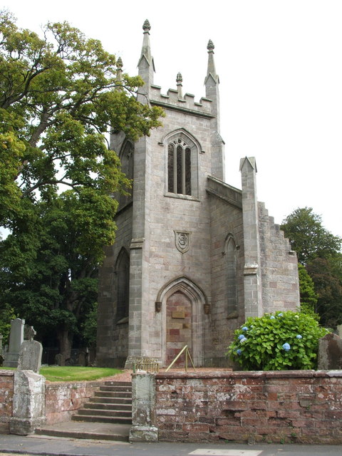
Image: © Lairich Rig Taken: 15 Aug 2007
See Image for a wider view, on a day with better lighting. Click on the end-note title for other pictures of the church and its churchyard. As is summarised in the end-note, the parish church for Cardross had been, until 1643, St Serf's (Image), which is in Levengrove Park, now part of the town of Dumbarton. However, with the redrawing of parish boundaries, it became desirable to have the parish church in a more central location. The site chosen was the one shown in the present photograph. The first church built here dated from 1643-44. In 1826-27, it was replaced by another church (whose architect was James Dempster) on the same site. The picture shows that church, which is now disused. It fell into disuse after sustaining bomb damage during the Cardross Blitz of 1941. The nearby former Free Church on the corner of Station Road and Church Avenue became the new parish church: Image A small stone panel is visible on the walled-up doorway (Image); it bears an inscription: "To the glory of God the tower of this Church was restored as a witness to past faith and future hope / Summer 1999 / 'Look Forward in Faith'". On each side of the doorway, at about the same level as the panel with the inscription, darker details are visible; these are two carved stone heads: see Image and Image The Canmore link in the end-note refers to "two identical mausoleum enclosures, castellated and gunlooped, on the western margin of the burial plot"; these are the Image and the Image For views of other memorials in the churchyard, click on the end-note title.
Images are licensed for reuse under creativecommons.org/licenses/by-sa/2.0
Image Location
Latitude
55.959994
Longitude
-4.645836