Overview for School Road, DROITWICH, WR9 7EA
Introduction
Droitwich Spa (often abbreviated to Droitwich ) is an historic spa town in the Wychavon district in northern Worcestershire, England, on the River Salwarpe. It is located approximately 22 miles (35 km) south-west of Birmingham and 7 miles (11 km) north-east of Worcester.
The town was called Salinae in Roman times, then later called Wyche, derived from the Anglo-Saxon Hwicce kingdom, referred to as "Saltwich" according to Anglo-Saxon charters, with the Droit (meaning "right" in French) added when the town was given its charter on 1 August 1215 by King John. The "Spa" was added in the 19th century when John Corbett developed the town's spa facilities. The River Salwarpe running through Droitwich is likely derived from sal meaning "salt" and weorp which means "to throw up" - i.e. "the river which throws up salt" - which overflows from the salt brines.
The town is situated on massive deposits of salt, and salt has been extracted there since ancient times. The natural Droitwich brine contains 2+1⁄2 pounds per imperial gallon (0.25 kg/L) of salt; ten times stronger than sea water and rivaled only by the Dead Sea.
Summary for School Road, DROITWICH, WR9 7EA
Roadworks near WR9 7EA
Road Safety near WR9 7EA
Details of personal injury accidents in and around School Road, WR9 7EA that have been reported to West Mercia Police over the past 20 years.
Traffic Levels near WR9 7EA
View traffic levels near School Road, WR9 7EA from official Department for Transport counts.
Images taken near to School Road, WR9 7EA and the surrounding area
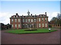
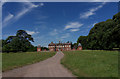
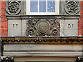
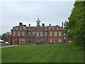
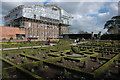
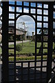

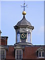
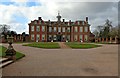

Please click the More button for more images, licensing and image copyright information.
Police
This area is policed by West Mercia Police.
West Mercia Police split their policing area into 82 separate neighbourhoods and this postcode is in the Chase and Priory neighbourhood.

Chase and Priory Neighbourhood Crime
Top 3 Categories
For full details of all categories together with more crime information, click on the Details button.
Member of UK Parliament
This postcode is in the Redditch parliamentary constituency.
Redditch is a constituency in the West Midlands region of England. The seat has been held by Rachel Maclean (Conservative) since June 2017.

Most Recent House Sales for School Road, WR9 7EA
17 Oct 2022
16 Jun 2021
24 Mar 2016
11 Aug 2014
Local Petrol Station Prices
Coordinates for WR9 7EA
Residents at WR9 7EA
Sunrise and Sunset at WR9 7EA
Traffic Emission and Congestion Zones
Historical Weather Summary
| Clear | 19.83% |
| Cloudy | 66.68% |
| Rain | 6.30% |
| Windy | 7.13% |
| Other | 0.06% |
Population
Deprivation Index
the more deprived the postcode
Average Energy Performance
Companies Registered at WR9 7EA
Postcode Details for WR9 7EA
Recent Updates
|
18 Apr 2024 Added Traffic Camera Views from Traffic Scotland to Roadworks within Scotland |
|
15 Apr 2024 Schools Data updated for April 2024 |
|
10 Apr 2024 Companies Data updated for March 2024 |
|
7 Apr 2024 New option to receive automatic updates to roadworks that affect you |
|
7 Apr 2024 Police and Crime data updated for February 2024 |
|
3 Apr 2024 Sold House Price data updated for February 2024 |
|
30 Mar 2024 Energy Performance Certificates (England and Wales) updated February 2024 |
|
28 Mar 2024 New feature to use Geolocating functions to detect your current location |
Random Postcodes
Want an idea of what is in our extensive website? Try somewhere completely random!
The Rural/Urban classification is based upon data collected during the 2011 Census and released in August 2013 and is categorised into 6 distinct classes.
[A] Urban Major conurbation: A built up area with a population of 10,000 (3,000 in Scotland) or more and is assigned to the major conurbation settlement category.
[B] Urban Minor conurbation: A built up area with a population of 10,000 (3,000 in Scotland) or more and is assigned to the minor conurbation settlement category.
[C] Urban City and town: A built up area with a population of 10,000 (3,000 in Scotland) or more and is assigned to the city and town settlement category.
[D] Rural Town and fringe
[E] Rural Village
[F] Rural Hamlet and isolated dwelling
The Index of Multiple Deprivation (IMD) is the official measure of relative deprivation.
The index is based on 39 separate indicators across seven distinct domains (Income; Employment; Health and Disability; Education, Skills and Training; Crime; Barriers to Housing and Services; Living Environment) to provide an overall measure of multiple deprivation and is calculated for every neighbourhood.
The index is relative rather than an absolute scale and so a neighbourhood with a score of 10 is more deprived than one rated 20, but this does not equate to being twice as deprived.
Please note: Different indices are used in England, Scotland, Wales and Northern Ireland and so comparison of scores from neighbourhoods in different countries should not be undertaken.
These figures report on incorporated UK companies only that are registered at this postcode and do not include sole-traders, partnerships or overseas organisations.
The population figure shown for your area are an estimate provided by the Office for National Statistics and is rounded to the nearest 1,000.
The estimates are derived from the Annual Population Survey (APS) which is the Labour Force Survey (LFS) plus various sample boosts.
There are 26 county councils in 2-tier areas, providing services such as education, social services and waste disposal.
In 2-tier areas, each county council area is subdivided into districts, for which there is an independent district council. There are 192 district councils.
District councils are responsible for local services such as rubbish collection, housing and planning applications.