Overview for Western Road, BRACKNELL, RG12 1TL
Introduction
Bracknell is a town and civil parish in Berkshire, England, the westernmost area within the Greater London Urban Area and the administrative centre of the borough of Bracknell Forest. It lies 11 miles (18 km) to the east of Reading, 9 miles (14 km) south of Maidenhead, 10 miles (16 km) southwest of Windsor and 25 miles (40 km) west of central London. Bracknell is the third largest town in Berkshire.
The name Bracknell is derived from the Saxon Braccan Heal or Braccan Heale, first recorded in a charter boundary of 942 AD. In the Middle Ages, Bracknell developed into two small market villages, Old Bracknoll and New Bracknoll. By the 19th century, the two Bracknells had combined into a singular market town, which was an important centre of local industry, most notably for its brick trade. In the 20th century, Bracknell experienced a period of rapid growth after it was declared a New Town. Planned at first for a population of 25,000, Bracknell New Town was further expanded in the 1960s to accommodate a population of 45,000. During this time, Bracknell absorbed many of its surrounding villages including Easthampstead, Ramslade and Old Bracknell. As of 2021, Bracknell Forest has an estimated population of around 113,205. Today, the town is a busy commercial centre within the so-called Silicon Thames Valley and the UK headquarters for several technology companies.
Bracknell is bordered to the south by Swinley Forest and by Crowthorne Woods to the south-east and south. Its neighbouring towns of Binfield, Warfield and Winkfield are part of the borough of Bracknell Forest and are gradually becoming absorbed into the Bracknell metropolitan area. To the east, the urban area joins up with Ascot to form a continuous conurbation that extends to Central London.
Summary for Western Road, BRACKNELL, RG12 1TL
Roadworks near RG12 1TL
Road Safety near RG12 1TL
Details of personal injury accidents in and around Western Road, RG12 1TL that have been reported to Thames Valley Police over the past 20 years.
Traffic Levels near RG12 1TL
View traffic levels near Western Road, RG12 1TL from official Department for Transport counts.
Images taken near to Western Road, RG12 1TL and the surrounding area

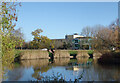
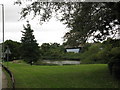
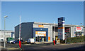
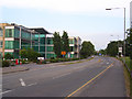
Please click the More button for more images, licensing and image copyright information.
Police
This area is policed by Thames Valley Police.
Thames Valley Police split their policing area into 108 separate neighbourhoods and this postcode is in the Bracknell Central North neighbourhood.

Bracknell Central North Neighbourhood Crime
Top 3 Categories
For full details of all categories together with more crime information, click on the Details button.
Member of UK Parliament
This postcode is in the Bracknell parliamentary constituency.
Bracknell is a constituency in the South East region of England. The seat has been held by James Sunderland (Conservative) since December 2019.

Most Recent House Sales for Western Road, RG12 1TL
4 May 1999
Local Petrol Station Prices
Coordinates for RG12 1TL
Residents at RG12 1TL
Sunrise and Sunset at RG12 1TL
Traffic Emission and Congestion Zones
Historical Weather Summary
| Clear | 22.25% |
| Cloudy | 68.17% |
| Rain | 6.44% |
| Windy | 2.97% |
| Other | 0.17% |
Population
Deprivation Index
the more deprived the postcode
Companies Registered at RG12 1TL
Postcode Details for RG12 1TL
Recent Updates
|
15 Apr 2024 Schools Data updated for April 2024 |
|
10 Apr 2024 Companies Data updated for March 2024 |
|
7 Apr 2024 New option to receive automatic updates to roadworks that affect you |
|
7 Apr 2024 Police and Crime data updated for February 2024 |
|
3 Apr 2024 Sold House Price data updated for February 2024 |
|
30 Mar 2024 Energy Performance Certificates (England and Wales) updated February 2024 |
|
28 Mar 2024 New feature to use Geolocating functions to detect your current location |
|
17 Mar 2024 Schools Data updated for March 2024 |
Random Postcodes
Want an idea of what is in our extensive website? Try somewhere completely random!
The Rural/Urban classification is based upon data collected during the 2011 Census and released in August 2013 and is categorised into 6 distinct classes.
[A] Urban Major conurbation: A built up area with a population of 10,000 (3,000 in Scotland) or more and is assigned to the major conurbation settlement category.
[B] Urban Minor conurbation: A built up area with a population of 10,000 (3,000 in Scotland) or more and is assigned to the minor conurbation settlement category.
[C] Urban City and town: A built up area with a population of 10,000 (3,000 in Scotland) or more and is assigned to the city and town settlement category.
[D] Rural Town and fringe
[E] Rural Village
[F] Rural Hamlet and isolated dwelling
The Index of Multiple Deprivation (IMD) is the official measure of relative deprivation.
The index is based on 39 separate indicators across seven distinct domains (Income; Employment; Health and Disability; Education, Skills and Training; Crime; Barriers to Housing and Services; Living Environment) to provide an overall measure of multiple deprivation and is calculated for every neighbourhood.
The index is relative rather than an absolute scale and so a neighbourhood with a score of 10 is more deprived than one rated 20, but this does not equate to being twice as deprived.
Please note: Different indices are used in England, Scotland, Wales and Northern Ireland and so comparison of scores from neighbourhoods in different countries should not be undertaken.
These figures report on incorporated UK companies only that are registered at this postcode and do not include sole-traders, partnerships or overseas organisations.
The population figure shown for your area are an estimate provided by the Office for National Statistics and is rounded to the nearest 1,000.
The estimates are derived from the Annual Population Survey (APS) which is the Labour Force Survey (LFS) plus various sample boosts.
There are 55 unitary authorities. They provide all local government services in their areas. These are mainly in the cities, urban areas and larger towns although there are now 6 shire county councils that are unitary (ie have no district councils beneath them).