Overview for Cliff End Park, WADEBRIDGE, PL27 6UR
Introduction
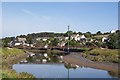
Wadebridge is a town and civil parish in north Cornwall, England, United Kingdom. The town straddles the River Camel five miles (eight kilometres) upstream from Padstow. The permanent population was 6,222 in the census of 2001, increasing to 7,900 in the 2011 census. There are two electoral wards in the town (East and West). Their total population is 8,272.
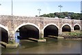
Originally known as Wade, it was a dangerous fording point across the river until a bridge was built here in the 15th century, after which the name changed to its present form. The bridge was strategically important during the English Civil War, and Oliver Cromwell went there to take it. Since then, it has been widened twice and refurbished in 1991.
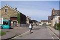
Wadebridge was served by a railway station between 1834 and 1967; part of the line now forms the Camel Trail, a recreational route for walkers, cyclists and horse riders. The town used to be a road traffic bottleneck on the A39 road until it was bypassed in 1991, and the main shopping street, Molesworth Street, is now pedestrianised.
The town has a secondary school where several notable sports-people were educated. The Royal Cornwall Show is a three-day agricultural show held at the nearby Royal Cornwall Showground every June, and the 5-day Cornwall Folk Festival takes place around the August Bank Holiday.
Summary for Cliff End Park, WADEBRIDGE, PL27 6UR
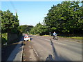
Roadworks near PL27 6UR
Road Safety near PL27 6UR
Details of personal injury accidents in and around Cliff End Park, PL27 6UR that have been reported to Devon & Cornwall Police over the past 20 years.
Traffic Levels near PL27 6UR
View traffic levels near Cliff End Park, PL27 6UR from official Department for Transport counts.
Images taken near to Cliff End Park, PL27 6UR and the surrounding area
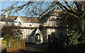
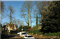
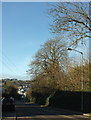
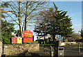
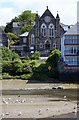
Please click the More button for more images, licensing and image copyright information.
Member of UK Parliament
This postcode is in the North Cornwall parliamentary constituency.
North Cornwall is a constituency in the South West region of England. The seat has been held by Scott Mann (Conservative) since May 2015.

Most Recent House Sales for Cliff End Park, PL27 6UR
12 Jan 2023
25 Mar 2015
31 Mar 2008
31 Aug 2007
Local Petrol Station Prices
Coordinates for PL27 6UR
Residents at PL27 6UR
Sunrise and Sunset at PL27 6UR
Traffic Emission and Congestion Zones
Historical Weather Summary
| Clear | 18.18% |
| Cloudy | 61.58% |
| Rain | 11.39% |
| Windy | 7.75% |
| Other | 1.10% |
Population
Deprivation Index
the more deprived the postcode
Average Energy Performance
Companies Registered at PL27 6UR
Postcode Details for PL27 6UR
Recent Updates
|
18 Apr 2024 Added Traffic Camera Views from Traffic Scotland to Roadworks within Scotland |
|
15 Apr 2024 Schools Data updated for April 2024 |
|
10 Apr 2024 Companies Data updated for March 2024 |
|
7 Apr 2024 New option to receive automatic updates to roadworks that affect you |
|
7 Apr 2024 Police and Crime data updated for February 2024 |
|
3 Apr 2024 Sold House Price data updated for February 2024 |
|
30 Mar 2024 Energy Performance Certificates (England and Wales) updated February 2024 |
|
28 Mar 2024 New feature to use Geolocating functions to detect your current location |
Random Postcodes
Want an idea of what is in our extensive website? Try somewhere completely random!
The Rural/Urban classification is based upon data collected during the 2011 Census and released in August 2013 and is categorised into 6 distinct classes.
[A] Urban Major conurbation: A built up area with a population of 10,000 (3,000 in Scotland) or more and is assigned to the major conurbation settlement category.
[B] Urban Minor conurbation: A built up area with a population of 10,000 (3,000 in Scotland) or more and is assigned to the minor conurbation settlement category.
[C] Urban City and town: A built up area with a population of 10,000 (3,000 in Scotland) or more and is assigned to the city and town settlement category.
[D] Rural Town and fringe
[E] Rural Village
[F] Rural Hamlet and isolated dwelling
The Index of Multiple Deprivation (IMD) is the official measure of relative deprivation.
The index is based on 39 separate indicators across seven distinct domains (Income; Employment; Health and Disability; Education, Skills and Training; Crime; Barriers to Housing and Services; Living Environment) to provide an overall measure of multiple deprivation and is calculated for every neighbourhood.
The index is relative rather than an absolute scale and so a neighbourhood with a score of 10 is more deprived than one rated 20, but this does not equate to being twice as deprived.
Please note: Different indices are used in England, Scotland, Wales and Northern Ireland and so comparison of scores from neighbourhoods in different countries should not be undertaken.
These figures report on incorporated UK companies only that are registered at this postcode and do not include sole-traders, partnerships or overseas organisations.
The population figure shown for your area are an estimate provided by the Office for National Statistics and is rounded to the nearest 1,000.
The estimates are derived from the Annual Population Survey (APS) which is the Labour Force Survey (LFS) plus various sample boosts.
There are 55 unitary authorities. They provide all local government services in their areas. These are mainly in the cities, urban areas and larger towns although there are now 6 shire county councils that are unitary (ie have no district councils beneath them).