Overview for Sandbank Road, DUNOON, PA23 7RR
Introduction
Dunoon is the main town on the Cowal peninsula in the south of Argyll and Bute, Scotland. It is located on the western shore of the upper Firth of Clyde, to the south of the Holy Loch and to the north of Innellan. As well as forming part of the council area of Argyll and Bute, Dunoon also has its own community council. Dunoon was a burgh until 1976.
The early history of Dunoon often revolves around two feuding clans: the Lamonts and the Campbells. Dunoon was a popular destination when travel by steamships was common around the Firth of Clyde; Glaswegians described this as going doon the watter. This diminished, and many holidaymakers started to go elsewhere as roads and railways improved and the popularity of overseas travel increased.
In 1961, during the height of the Cold War, Dunoon became a garrison town to the United States Navy. In 1992, shortly after the dissolution of the Soviet Union, they closed their Holy Loch base in Sandbank, and neighbouring Dunoon suffered an economic downturn. Since the base's closure, the town and surrounding area are again turning to tourism, marketing to outdoor enthusiasts and wildlife lovers, as well as promoting festivals and competitions. The largest annual event held in the town is the Cowal Highland Gathering, which has been held since 1894. The Royal National Mòd has also been held in the town.
Summary for Sandbank Road, DUNOON, PA23 7RR
Roadworks near PA23 7RR
Road Safety near PA23 7RR
Details of personal injury accidents in and around Sandbank Road, PA23 7RR that have been reported to over the past 20 years.
Traffic Levels near PA23 7RR
View traffic levels near Sandbank Road, PA23 7RR from official Department for Transport counts.
Images taken near to Sandbank Road, PA23 7RR and the surrounding area
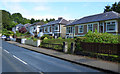
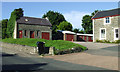

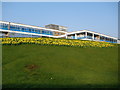

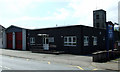
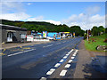

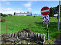
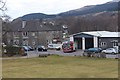
Please click the More button for more images, licensing and image copyright information.
Member of UK Parliament
This postcode is in the Argyll and Bute parliamentary constituency.
Argyll and Bute is a constituency in Scotland. The seat has been held by Brendan O'Hara (Scottish National Party) since May 2015.

Most Recent House Sales for Sandbank Road, PA23 7RR
No recorded house sales or transfers for this postcode.
Local Petrol Station Prices
Coordinates for PA23 7RR
Sunrise and Sunset at PA23 7RR
Traffic Emission and Congestion Zones
Historical Weather Summary
| Clear | 4.72% |
| Cloudy | 55.35% |
| Rain | 17.49% |
| Windy | 21.90% |
| Other | 0.54% |
Average Energy Performance
Companies Registered at PA23 7RR
Postcode Details for PA23 7RR
Recent Updates
|
18 Apr 2024 Added Traffic Camera Views from Traffic Scotland to Roadworks within Scotland |
|
15 Apr 2024 Schools Data updated for April 2024 |
|
10 Apr 2024 Companies Data updated for March 2024 |
|
7 Apr 2024 New option to receive automatic updates to roadworks that affect you |
|
7 Apr 2024 Police and Crime data updated for February 2024 |
|
3 Apr 2024 Sold House Price data updated for February 2024 |
|
30 Mar 2024 Energy Performance Certificates (England and Wales) updated February 2024 |
|
28 Mar 2024 New feature to use Geolocating functions to detect your current location |
Random Postcodes
Want an idea of what is in our extensive website? Try somewhere completely random!
The Rural/Urban classification is based upon data collected during the 2011 Census and released in August 2013 and is categorised into 6 distinct classes.
[A] Urban Major conurbation: A built up area with a population of 10,000 (3,000 in Scotland) or more and is assigned to the major conurbation settlement category.
[B] Urban Minor conurbation: A built up area with a population of 10,000 (3,000 in Scotland) or more and is assigned to the minor conurbation settlement category.
[C] Urban City and town: A built up area with a population of 10,000 (3,000 in Scotland) or more and is assigned to the city and town settlement category.
[D] Rural Town and fringe
[E] Rural Village
[F] Rural Hamlet and isolated dwelling
The Index of Multiple Deprivation (IMD) is the official measure of relative deprivation.
The index is based on 39 separate indicators across seven distinct domains (Income; Employment; Health and Disability; Education, Skills and Training; Crime; Barriers to Housing and Services; Living Environment) to provide an overall measure of multiple deprivation and is calculated for every neighbourhood.
The index is relative rather than an absolute scale and so a neighbourhood with a score of 10 is more deprived than one rated 20, but this does not equate to being twice as deprived.
Please note: Different indices are used in England, Scotland, Wales and Northern Ireland and so comparison of scores from neighbourhoods in different countries should not be undertaken.
These figures report on incorporated UK companies only that are registered at this postcode and do not include sole-traders, partnerships or overseas organisations.
The population figure shown for your area are an estimate provided by the Office for National Statistics and is rounded to the nearest 1,000.
The estimates are derived from the Annual Population Survey (APS) which is the Labour Force Survey (LFS) plus various sample boosts.
There are 55 unitary authorities. They provide all local government services in their areas. These are mainly in the cities, urban areas and larger towns although there are now 6 shire county councils that are unitary (ie have no district councils beneath them).