Overview for Porterfield Road, KILMACOLM, PA13 4PD
Introduction
Kilmacolm is a village and civil parish in the Inverclyde council area, and the historic county of Renfrewshire in the west central Lowlands of Scotland. It lies on the northern slope of the Gryffe Valley, 7+1⁄2 miles (12 kilometres) southeast of Greenock and around 15 miles (24 km) west of the city of Glasgow. The village has a population of around 4,000 and is part of a wider civil parish which covers a large rural hinterland of 15,000 hectares (150 km2; 58 sq mi) containing within it the smaller settlement of Quarrier's Village, originally established as a 19th-century residential orphans' home.
The area surrounding the village was settled in prehistoric times and emerged as part of a feudal society with the parish divided between separate estates for much of its history. The village itself remained small, providing services to nearby farm communities and acting as a religious hub for the parish. The name of the village derives from the Scottish Gaelic Cill MoCholuim, indicating the dedication of its church to St Columba. The parish church was mentioned in a papal bull of 1225 showing its appropriation to Paisley Abbey, and it sits on the site of an ancient religious community dating to the 5th or 6th centuries. Again in the 13th century, Duchal Castle was constructed in the parish and is notable for being besieged by King James IV of Scotland in 1489, following the resident Lyle family's support of an insurrection against him. Feuding between the noble families of Kilmacolm was commonplace in the Middle Ages, and in the 16th and 17th centuries, the parish again came to the attention of the Crown for providing support to outlawed religious Covenanters.
The character of the village changed significantly in the Victorian era, with the arrival of the railway in Kilmacolm in 1869. Many of Kilmacolm's modern buildings were constructed between this date and the outbreak of World War I. The emergence of such transport links enabled the village to expand as an affluent dormitory village serving the nearby urban centres of Glasgow, Paisley and Greenock. The economy of the village reflected this population change, moving away from its traditional reliance on agriculture to providing tertiary sector services to residents and visitors.
Summary for Porterfield Road, KILMACOLM, PA13 4PD
Roadworks near PA13 4PD
Road Safety near PA13 4PD
Details of personal injury accidents in and around Porterfield Road, PA13 4PD that have been reported to over the past 20 years.
Traffic Levels near PA13 4PD
View traffic levels near Porterfield Road, PA13 4PD from official Department for Transport counts.
Images taken near to Porterfield Road, PA13 4PD and the surrounding area
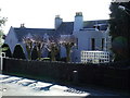

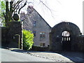
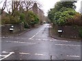
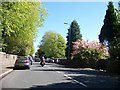
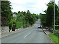
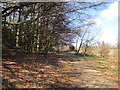
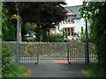
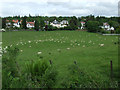
Please click the More button for more images, licensing and image copyright information.
Member of UK Parliament
This postcode is in the Inverclyde parliamentary constituency.
Inverclyde is a constituency in Scotland. The seat has been held by Ronnie Cowan (Scottish National Party) since May 2015.

Most Recent House Sales for Porterfield Road, PA13 4PD
No recorded house sales or transfers for this postcode.
Local Petrol Station Prices
Coordinates for PA13 4PD
Sunrise and Sunset at PA13 4PD
Traffic Emission and Congestion Zones
Historical Weather Summary
| Clear | 5.30% |
| Cloudy | 56.20% |
| Rain | 15.37% |
| Windy | 22.70% |
| Other | 0.43% |
Average Energy Performance
Companies Registered at PA13 4PD
Postcode Details for PA13 4PD
Recent Updates
|
18 Apr 2024 Added Traffic Camera Views from Traffic Scotland to Roadworks within Scotland |
|
15 Apr 2024 Schools Data updated for April 2024 |
|
10 Apr 2024 Companies Data updated for March 2024 |
|
7 Apr 2024 New option to receive automatic updates to roadworks that affect you |
|
7 Apr 2024 Police and Crime data updated for February 2024 |
|
3 Apr 2024 Sold House Price data updated for February 2024 |
|
30 Mar 2024 Energy Performance Certificates (England and Wales) updated February 2024 |
|
28 Mar 2024 New feature to use Geolocating functions to detect your current location |
Random Postcodes
Want an idea of what is in our extensive website? Try somewhere completely random!
The Rural/Urban classification is based upon data collected during the 2011 Census and released in August 2013 and is categorised into 6 distinct classes.
[A] Urban Major conurbation: A built up area with a population of 10,000 (3,000 in Scotland) or more and is assigned to the major conurbation settlement category.
[B] Urban Minor conurbation: A built up area with a population of 10,000 (3,000 in Scotland) or more and is assigned to the minor conurbation settlement category.
[C] Urban City and town: A built up area with a population of 10,000 (3,000 in Scotland) or more and is assigned to the city and town settlement category.
[D] Rural Town and fringe
[E] Rural Village
[F] Rural Hamlet and isolated dwelling
The Index of Multiple Deprivation (IMD) is the official measure of relative deprivation.
The index is based on 39 separate indicators across seven distinct domains (Income; Employment; Health and Disability; Education, Skills and Training; Crime; Barriers to Housing and Services; Living Environment) to provide an overall measure of multiple deprivation and is calculated for every neighbourhood.
The index is relative rather than an absolute scale and so a neighbourhood with a score of 10 is more deprived than one rated 20, but this does not equate to being twice as deprived.
Please note: Different indices are used in England, Scotland, Wales and Northern Ireland and so comparison of scores from neighbourhoods in different countries should not be undertaken.
These figures report on incorporated UK companies only that are registered at this postcode and do not include sole-traders, partnerships or overseas organisations.
The population figure shown for your area are an estimate provided by the Office for National Statistics and is rounded to the nearest 1,000.
The estimates are derived from the Annual Population Survey (APS) which is the Labour Force Survey (LFS) plus various sample boosts.
There are 55 unitary authorities. They provide all local government services in their areas. These are mainly in the cities, urban areas and larger towns although there are now 6 shire county councils that are unitary (ie have no district councils beneath them).