Overview for MOELFRE, LL72 8HH
Introduction
Moelfre ([ˈmɔɨ̯lvrɛ] ) is a village, a community and, until 2012, an electoral ward on the north-east coast of the Isle of Anglesey in Wales. The community area covers the village and harbour, and several smaller, dispersed settlements. It includes six scheduled Iron Age hut groups and many other sites of archaeological interest. The harbour was formerly a local fishing port; a lifeboat station has been based here since 1854. Among many shipwrecks off the coast was that of the Royal Charter in 1859. Near the modernised lifeboat station is the RNLI Seawatch Centre. The coastline includes a rocky headland north of the village and a large sandy beach at Lligwy Bay, both traversed by the Anglesey Coastal Path. The 2011 census measured the village population as 710. It was estimated at 614 in 2019.
Summary for MOELFRE, LL72 8HH
Roadworks near LL72 8HH
A local roadworks feed is not available for Wales at this time.
However, Traffic Wales/Traffig Cymru provide works details for motorways and major trunk roads in Wales on their website at traffic.wales/roadworks
Road Safety near LL72 8HH
Details of personal injury accidents in and around LL72 8HH that have been reported to North Wales Police over the past 20 years.
Traffic Levels near LL72 8HH
View traffic levels near LL72 8HH from official Department for Transport counts.
Images taken in and around the ll728hh area
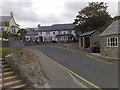
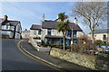
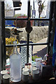

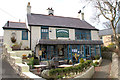
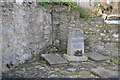

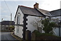
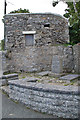
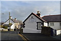
Please click the More button for more images, licensing and image copyright information.
Member of UK Parliament
This postcode is in the Ynys Môn parliamentary constituency.
Ynys Môn is a constituency in Wales. The seat has been held by Virginia Crosbie (Conservative) since December 2019.

Most Recent House Sales for LL72 8HH
16 Mar 2023
9 Sep 2022
19 Apr 2022
27 Sep 2019
Local Petrol Station Prices
Coordinates for LL72 8HH
Residents at LL72 8HH
Sunrise and Sunset at LL72 8HH
Traffic Emission and Congestion Zones
Historical Weather Summary
| Clear | 13.89% |
| Cloudy | 63.78% |
| Rain | 10.22% |
| Windy | 10.85% |
| Other | 1.26% |
Population
Deprivation Index
the more deprived the postcode
Average Energy Performance
Companies Registered at LL72 8HH
Postcode Details for LL72 8HH
Recent Updates
|
18 Apr 2024 Added Traffic Camera Views from Traffic Scotland to Roadworks within Scotland |
|
15 Apr 2024 Schools Data updated for April 2024 |
|
10 Apr 2024 Companies Data updated for March 2024 |
|
7 Apr 2024 New option to receive automatic updates to roadworks that affect you |
|
7 Apr 2024 Police and Crime data updated for February 2024 |
|
3 Apr 2024 Sold House Price data updated for February 2024 |
|
30 Mar 2024 Energy Performance Certificates (England and Wales) updated February 2024 |
|
28 Mar 2024 New feature to use Geolocating functions to detect your current location |
Random Postcodes
Want an idea of what is in our extensive website? Try somewhere completely random!
The Rural/Urban classification is based upon data collected during the 2011 Census and released in August 2013 and is categorised into 6 distinct classes.
[A] Urban Major conurbation: A built up area with a population of 10,000 (3,000 in Scotland) or more and is assigned to the major conurbation settlement category.
[B] Urban Minor conurbation: A built up area with a population of 10,000 (3,000 in Scotland) or more and is assigned to the minor conurbation settlement category.
[C] Urban City and town: A built up area with a population of 10,000 (3,000 in Scotland) or more and is assigned to the city and town settlement category.
[D] Rural Town and fringe
[E] Rural Village
[F] Rural Hamlet and isolated dwelling
The Index of Multiple Deprivation (IMD) is the official measure of relative deprivation.
The index is based on 39 separate indicators across seven distinct domains (Income; Employment; Health and Disability; Education, Skills and Training; Crime; Barriers to Housing and Services; Living Environment) to provide an overall measure of multiple deprivation and is calculated for every neighbourhood.
The index is relative rather than an absolute scale and so a neighbourhood with a score of 10 is more deprived than one rated 20, but this does not equate to being twice as deprived.
Please note: Different indices are used in England, Scotland, Wales and Northern Ireland and so comparison of scores from neighbourhoods in different countries should not be undertaken.
These figures report on incorporated UK companies only that are registered at this postcode and do not include sole-traders, partnerships or overseas organisations.
The population figure shown for your area are an estimate provided by the Office for National Statistics and is rounded to the nearest 1,000.
The estimates are derived from the Annual Population Survey (APS) which is the Labour Force Survey (LFS) plus various sample boosts.
There are 55 unitary authorities. They provide all local government services in their areas. These are mainly in the cities, urban areas and larger towns although there are now 6 shire county councils that are unitary (ie have no district councils beneath them).