Overview for ABERDOVEY, LL35 0RY
Introduction
Aberdyfi, also known as Aberdovey (a-bər-DUH-vee), is a village and community in Gwynedd, Wales, located on the northern side of the estuary of the River Dyfi.
The population of the community was 878 at the 2011 census. The electoral ward had a larger population of 1,282 and includes the community of Pennal.
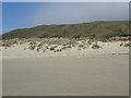
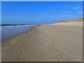
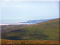
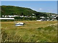
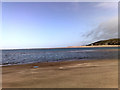
Founded by shipbuilding, Aberdyfi is now a seaside resort with a high quality beach. The centre is on the river and seafront, around the original harbour, jetty and beach; it stretches back from the coast and up the steep hillside in the midst of typical Welsh coastal scenery of steep green hills and sheep farms. Penhelig railway station is in the eastern part of the village.
Being less than 100 miles (160 km) from the West Midlands, the area is popular with tourists. 43.3% of houses in the village are holiday homes. The village is located within the Snowdonia National Park.
In the 2011 census, 38.5% of the population of Aberdyfi ward identified themselves as Welsh (or combined). 59.4% of the population were born outside Wales. According to the 2021 census, 43.3% could speak Welsh with an increase of 0.7% from last time.
Summary for ABERDOVEY, LL35 0RY
Roadworks near LL35 0RY
A local roadworks feed is not available for Wales at this time.
However, Traffic Wales/Traffig Cymru provide works details for motorways and major trunk roads in Wales on their website at traffic.wales/roadworks
Road Safety near LL35 0RY
Details of personal injury accidents in and around LL35 0RY that have been reported to North Wales Police over the past 20 years.
Traffic Levels near LL35 0RY
View traffic levels near LL35 0RY from official Department for Transport counts.
Images taken in and around the ll350ry area
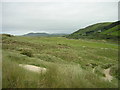
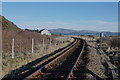
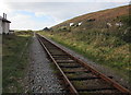
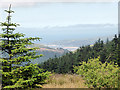
Please click the More button for more images, licensing and image copyright information.
Aberdovey and nearby Videos From YouTube
Aberdyfi Beach By Drone 【2.7K】 🚶 🇬🇧
aberdyfi #wales #droneflight ✔️ If you would like to help the channel here! https://www.paypal.me/steviesvlogs ✔️ If you ...
Channel: Badgers Walking Tours (View Channel)
Published: 27 Jan 2023
Member of UK Parliament
This postcode is in the Dwyfor Meirionnydd parliamentary constituency.
Dwyfor Meirionnydd is a constituency in Wales. The seat has been held by Liz Saville Roberts (Plaid Cymru) since May 2015.

Most Recent House Sales for LL35 0RY
6 Oct 2021
24 Sep 2021
18 Dec 2020
1 Dec 2017
Local Petrol Station Prices
Coordinates for LL35 0RY
Residents at LL35 0RY
Sunrise and Sunset at LL35 0RY
Traffic Emission and Congestion Zones
Historical Weather Summary
| Clear | 16.44% |
| Cloudy | 65.27% |
| Rain | 9.39% |
| Windy | 8.79% |
| Other | 0.11% |
Population
Deprivation Index
the more deprived the postcode
Average Energy Performance
Companies Registered at LL35 0RY
National Park for LL35 0RY
Postcode Details for LL35 0RY
Recent Updates
|
18 Apr 2024 Added Traffic Camera Views from Traffic Scotland to Roadworks within Scotland |
|
15 Apr 2024 Schools Data updated for April 2024 |
|
10 Apr 2024 Companies Data updated for March 2024 |
|
7 Apr 2024 New option to receive automatic updates to roadworks that affect you |
|
7 Apr 2024 Police and Crime data updated for February 2024 |
|
3 Apr 2024 Sold House Price data updated for February 2024 |
|
30 Mar 2024 Energy Performance Certificates (England and Wales) updated February 2024 |
|
28 Mar 2024 New feature to use Geolocating functions to detect your current location |
Random Postcodes
Want an idea of what is in our extensive website? Try somewhere completely random!
The Rural/Urban classification is based upon data collected during the 2011 Census and released in August 2013 and is categorised into 6 distinct classes.
[A] Urban Major conurbation: A built up area with a population of 10,000 (3,000 in Scotland) or more and is assigned to the major conurbation settlement category.
[B] Urban Minor conurbation: A built up area with a population of 10,000 (3,000 in Scotland) or more and is assigned to the minor conurbation settlement category.
[C] Urban City and town: A built up area with a population of 10,000 (3,000 in Scotland) or more and is assigned to the city and town settlement category.
[D] Rural Town and fringe
[E] Rural Village
[F] Rural Hamlet and isolated dwelling
The Index of Multiple Deprivation (IMD) is the official measure of relative deprivation.
The index is based on 39 separate indicators across seven distinct domains (Income; Employment; Health and Disability; Education, Skills and Training; Crime; Barriers to Housing and Services; Living Environment) to provide an overall measure of multiple deprivation and is calculated for every neighbourhood.
The index is relative rather than an absolute scale and so a neighbourhood with a score of 10 is more deprived than one rated 20, but this does not equate to being twice as deprived.
Please note: Different indices are used in England, Scotland, Wales and Northern Ireland and so comparison of scores from neighbourhoods in different countries should not be undertaken.
These figures report on incorporated UK companies only that are registered at this postcode and do not include sole-traders, partnerships or overseas organisations.
The population figure shown for your area are an estimate provided by the Office for National Statistics and is rounded to the nearest 1,000.
The estimates are derived from the Annual Population Survey (APS) which is the Labour Force Survey (LFS) plus various sample boosts.
There are 55 unitary authorities. They provide all local government services in their areas. These are mainly in the cities, urban areas and larger towns although there are now 6 shire county councils that are unitary (ie have no district councils beneath them).