Overview for Lound Road, KENDAL, LA9 7EG
Introduction
Kendal, once Kirkby in Kendal or Kirkby Kendal, is a market town and civil parish in the Westmorland and Furness district of Cumbria, England. It lies within the River Kent's dale, from which its name is derived from, just outside the boundary of the Lake District National Park.
In the Domesday Book of 1086, the area was collected under Yorkshire. The area came under the Honour of Lancaster before the barony split. The town became the Barony of Kendal's seat, in 1226/7 this barony merged with the Barony of Westmorland to form the historic county of Westmorland with Appleby as the historic county town. From 1889–1974, it became the county town. Under the 1974 reforms, it became the administrative centre of the South Lakeland district. The town became Westmorland and Furness district's administrative centre in a 2023 reform.
It is 8 miles (13 km) south-east of Windermere and 19 miles (31 km) north of Lancaster. At the 2011 Census, the town had a population of 28,586, making it the second largest town in Westmorland and Furness after Barrow-in-Furness. It is renowned today mainly as a centre for shopping, for its festivals and historic sights, including Kendal Castle, and as the home of Kendal Mint Cake. The town's grey limestone buildings have earned it the sobriquet "Auld Grey Town".
Summary for Lound Road, KENDAL, LA9 7EG
Roadworks near LA9 7EG
Road Safety near LA9 7EG
Details of personal injury accidents in and around Lound Road, LA9 7EG that have been reported to Cumbria Constabulary over the past 20 years.
Traffic Levels near LA9 7EG
View traffic levels near Lound Road, LA9 7EG from official Department for Transport counts.
Images taken near to Lound Road, LA9 7EG and the surrounding area

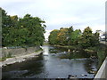

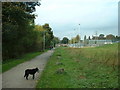
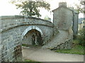
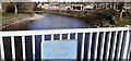

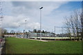
Please click the More button for more images, licensing and image copyright information.
Police
This area is policed by Cumbria Constabulary.
Cumbria Constabulary split their policing area into 33 separate neighbourhoods and this postcode is in the Kendal, Burneside and Endmoor neighbourhood.

Kendal, Burneside and Endmoor Neighbourhood Crime
Top 3 Categories
For full details of all categories together with more crime information, click on the Details button.
Member of UK Parliament
This postcode is in the Westmorland and Lonsdale parliamentary constituency.
Westmorland and Lonsdale is a constituency in the North West region of England. The seat has been held by Tim Farron (Liberal Democrat) since May 2010.

Most Recent House Sales for Lound Road, LA9 7EG
29 Oct 2015
17 Aug 2007
18 May 2007
6 Aug 2004
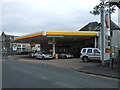
Local Petrol Station Prices
Coordinates for LA9 7EG
Residents at LA9 7EG
Sunrise and Sunset at LA9 7EG
Traffic Emission and Congestion Zones
Historical Weather Summary
| Clear | 7.41% |
| Cloudy | 63.31% |
| Rain | 15.37% |
| Windy | 12.55% |
| Other | 1.36% |
Deprivation Index
the more deprived the postcode
Average Energy Performance
Companies Registered at LA9 7EG
Postcode Details for LA9 7EG
Recent Updates
|
18 Apr 2024 Added Traffic Camera Views from Traffic Scotland to Roadworks within Scotland |
|
15 Apr 2024 Schools Data updated for April 2024 |
|
10 Apr 2024 Companies Data updated for March 2024 |
|
7 Apr 2024 New option to receive automatic updates to roadworks that affect you |
|
7 Apr 2024 Police and Crime data updated for February 2024 |
|
3 Apr 2024 Sold House Price data updated for February 2024 |
|
30 Mar 2024 Energy Performance Certificates (England and Wales) updated February 2024 |
|
28 Mar 2024 New feature to use Geolocating functions to detect your current location |
Random Postcodes
Want an idea of what is in our extensive website? Try somewhere completely random!
The Rural/Urban classification is based upon data collected during the 2011 Census and released in August 2013 and is categorised into 6 distinct classes.
[A] Urban Major conurbation: A built up area with a population of 10,000 (3,000 in Scotland) or more and is assigned to the major conurbation settlement category.
[B] Urban Minor conurbation: A built up area with a population of 10,000 (3,000 in Scotland) or more and is assigned to the minor conurbation settlement category.
[C] Urban City and town: A built up area with a population of 10,000 (3,000 in Scotland) or more and is assigned to the city and town settlement category.
[D] Rural Town and fringe
[E] Rural Village
[F] Rural Hamlet and isolated dwelling
The Index of Multiple Deprivation (IMD) is the official measure of relative deprivation.
The index is based on 39 separate indicators across seven distinct domains (Income; Employment; Health and Disability; Education, Skills and Training; Crime; Barriers to Housing and Services; Living Environment) to provide an overall measure of multiple deprivation and is calculated for every neighbourhood.
The index is relative rather than an absolute scale and so a neighbourhood with a score of 10 is more deprived than one rated 20, but this does not equate to being twice as deprived.
Please note: Different indices are used in England, Scotland, Wales and Northern Ireland and so comparison of scores from neighbourhoods in different countries should not be undertaken.
These figures report on incorporated UK companies only that are registered at this postcode and do not include sole-traders, partnerships or overseas organisations.
The population figure shown for your area are an estimate provided by the Office for National Statistics and is rounded to the nearest 1,000.
The estimates are derived from the Annual Population Survey (APS) which is the Labour Force Survey (LFS) plus various sample boosts.
There are 55 unitary authorities. They provide all local government services in their areas. These are mainly in the cities, urban areas and larger towns although there are now 6 shire county councils that are unitary (ie have no district councils beneath them).