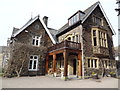
Overview for Holbeck Ghyll, WINDERMERE, LA23 1LU
Introduction
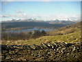
Windermere (sometimes tautologically called Lake Windermere to distinguish it from the nearby town of Windermere) is a ribbon lake in Cumbria, England and part of the Lake District. It is the largest lake in England by length, area, and volume, but considerably smaller than the largest Scottish lochs and Northern Irish loughs.
The lake is about 11 miles (18 km) in length and 1 mile (1.6 km) at its widest, has a maximum depth of 64 metres (210 ft), and has an elevation of 39 metres (128 ft) above sea level. Its outflow is the River Leven, which drains into Morecambe Bay. The lake is in the administrative council area of Westmorland and Furness and the historic county of Westmorland, with the lake forming part of the boundary between the historic counties of Westmorland and Lancashire. It has been one of the country's most popular places for holidays and summer homes since the arrival of the Kendal and Windermere Railway's branch line in 1847. The Freshwater Biological Association was established on the shore of Windermere in 1929 and much of the early work on lake ecology, freshwater biology and limnology was conducted here.
Summary for Holbeck Ghyll, WINDERMERE, LA23 1LU
Roadworks near LA23 1LU
Road Safety near LA23 1LU
Details of personal injury accidents in and around Holbeck Ghyll, LA23 1LU that have been reported to Cumbria Constabulary over the past 20 years.
Traffic Levels near LA23 1LU
View traffic levels near Holbeck Ghyll, LA23 1LU from official Department for Transport counts.
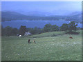
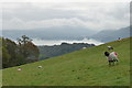
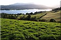
Images taken near to Holbeck Ghyll, LA23 1LU and the surrounding area

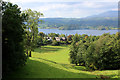
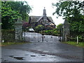
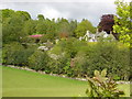
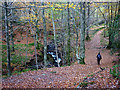
Please click the More button for more images, licensing and image copyright information.
Police
This area is policed by Cumbria Constabulary.
Cumbria Constabulary split their policing area into 33 separate neighbourhoods and this postcode is in the Windermere, Ambleside, Grasmere and Staveley neighbourhood.

Windermere, Ambleside, Grasmere and Staveley Neighbourhood Crime
Top 3 Categories
For full details of all categories together with more crime information, click on the Details button.
Member of UK Parliament
This postcode is in the Westmorland and Lonsdale parliamentary constituency.
Westmorland and Lonsdale is a constituency in the North West region of England. The seat has been held by Tim Farron (Liberal Democrat) since May 2010.

Most Recent House Sales for Holbeck Ghyll, LA23 1LU
6 Jun 2020
15 Nov 2019
19 Dec 2014
3 May 2012
Local Petrol Station Prices
Coordinates for LA23 1LU
Residents at LA23 1LU
Sunrise and Sunset at LA23 1LU
Traffic Emission and Congestion Zones
Historical Weather Summary
| Clear | 6.60% |
| Cloudy | 60.83% |
| Rain | 14.68% |
| Windy | 15.46% |
| Other | 2.43% |
Deprivation Index
the more deprived the postcode
Average Energy Performance
Companies Registered at LA23 1LU
National Park for LA23 1LU
Postcode Details for LA23 1LU
Recent Updates
|
18 Apr 2024 Added Traffic Camera Views from Traffic Scotland to Roadworks within Scotland |
|
15 Apr 2024 Schools Data updated for April 2024 |
|
10 Apr 2024 Companies Data updated for March 2024 |
|
7 Apr 2024 New option to receive automatic updates to roadworks that affect you |
|
7 Apr 2024 Police and Crime data updated for February 2024 |
|
3 Apr 2024 Sold House Price data updated for February 2024 |
|
30 Mar 2024 Energy Performance Certificates (England and Wales) updated February 2024 |
|
28 Mar 2024 New feature to use Geolocating functions to detect your current location |
Random Postcodes
Want an idea of what is in our extensive website? Try somewhere completely random!
The Rural/Urban classification is based upon data collected during the 2011 Census and released in August 2013 and is categorised into 6 distinct classes.
[A] Urban Major conurbation: A built up area with a population of 10,000 (3,000 in Scotland) or more and is assigned to the major conurbation settlement category.
[B] Urban Minor conurbation: A built up area with a population of 10,000 (3,000 in Scotland) or more and is assigned to the minor conurbation settlement category.
[C] Urban City and town: A built up area with a population of 10,000 (3,000 in Scotland) or more and is assigned to the city and town settlement category.
[D] Rural Town and fringe
[E] Rural Village
[F] Rural Hamlet and isolated dwelling
The Index of Multiple Deprivation (IMD) is the official measure of relative deprivation.
The index is based on 39 separate indicators across seven distinct domains (Income; Employment; Health and Disability; Education, Skills and Training; Crime; Barriers to Housing and Services; Living Environment) to provide an overall measure of multiple deprivation and is calculated for every neighbourhood.
The index is relative rather than an absolute scale and so a neighbourhood with a score of 10 is more deprived than one rated 20, but this does not equate to being twice as deprived.
Please note: Different indices are used in England, Scotland, Wales and Northern Ireland and so comparison of scores from neighbourhoods in different countries should not be undertaken.
These figures report on incorporated UK companies only that are registered at this postcode and do not include sole-traders, partnerships or overseas organisations.
The population figure shown for your area are an estimate provided by the Office for National Statistics and is rounded to the nearest 1,000.
The estimates are derived from the Annual Population Survey (APS) which is the Labour Force Survey (LFS) plus various sample boosts.
There are 55 unitary authorities. They provide all local government services in their areas. These are mainly in the cities, urban areas and larger towns although there are now 6 shire county councils that are unitary (ie have no district councils beneath them).