Overview for Duke Street, BARROW-IN-FURNESS, LA14 1XS
Introduction
Barrow-in-Furness is a port town in Cumbria, England. Historically in Lancashire, it was incorporated as a municipal borough in 1867 and merged with Dalton-in-Furness Urban District in 1974 to form the Borough of Barrow-in-Furness. In 2023, the borough merged with Eden and South Lakeland districts to form a new unitary authority: Westmorland and Furness. At the tip of the Furness peninsula, close to the Lake District, it is bordered by Morecambe Bay, the Duddon Estuary and the Irish Sea. In 2011, Barrow's population was 56,745, making it the second largest urban area in Cumbria after Carlisle, and the largest in the Westmorland and Furness unitary authority.
Natives of Barrow, as well as the local dialect, are known as Barrovian. In the Middle Ages, Barrow was a small hamlet within the parish of Dalton-in-Furness with Furness Abbey, now on the outskirts of the town, controlling the local economy before its dissolution in 1537. The iron prospector Henry Schneider arrived in Furness in 1839 and, with other investors, opened the Furness Railway in 1846 to transport iron ore and slate from local mines to the coast. Further hematite deposits were discovered, of sufficient size to develop factories for smelting and exporting steel. For a period in the late 19th century, the Barrow Hematite Steel Company-owned steelworks was the world's largest.
Barrow's location and the availability of steel allowed the town to develop into a significant producer of naval vessels, a shift that was accelerated during World War I and the local yard's specialisation in submarines. The original iron- and steel-making enterprises closed down after World War II, leaving Vickers shipyard as Barrow's main industry and employer. Several Royal Navy flagships, the vast majority of its nuclear submarines as well as numerous other naval vessels, ocean liners and oil tankers have been manufactured at the facility.
The end of the Cold War and subsequent decrease in military spending saw high unemployment in the town through lack of contracts; despite this, the BAE Systems shipyard remains operational as the UK's largest by workforce (9,500 employees in 2020) and is now undergoing a major expansion associated with the Dreadnought-class submarine programme. Furthermore, in 2023 it was announced that a new class of nuclear submarine, associated with the trilateral AUKUS military alliance, will be designed and principally constructed in Barrow.
Today Barrow is also a hub for energy generation and handling. Offshore wind farms form one of the highest concentrations of turbines in the world, including the second largest offshore farm, with multiple operating bases in Barrow.
Summary for Duke Street, BARROW-IN-FURNESS, LA14 1XS
Roadworks near LA14 1XS
Road Safety near LA14 1XS
Details of personal injury accidents in and around Duke Street, LA14 1XS that have been reported to Cumbria Constabulary over the past 20 years.
Traffic Levels near LA14 1XS
View traffic levels near Duke Street, LA14 1XS from official Department for Transport counts.
Images taken near to Duke Street, LA14 1XS and the surrounding area
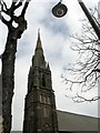
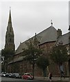
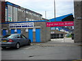
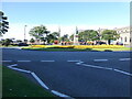

Please click the More button for more images, licensing and image copyright information.
Police
This area is policed by Cumbria Constabulary.
Cumbria Constabulary split their policing area into 33 separate neighbourhoods and this postcode is in the Barrow Central and Hindpool neighbourhood.

Barrow Central and Hindpool Neighbourhood Crime
Top 3 Categories
For full details of all categories together with more crime information, click on the Details button.
Member of UK Parliament
This postcode is in the Barrow and Furness parliamentary constituency.
Barrow and Furness is a constituency in the North West region of England. The seat has been held by Simon Fell (Conservative) since December 2019.

Most Recent House Sales for Duke Street, LA14 1XS
No recorded house sales or transfers for this postcode.
Local Petrol Station Prices
Coordinates for LA14 1XS
Residents at LA14 1XS
Sunrise and Sunset at LA14 1XS
Traffic Emission and Congestion Zones
Historical Weather Summary
| Clear | 18.09% |
| Cloudy | 58.16% |
| Rain | 8.43% |
| Windy | 15.10% |
| Other | 0.22% |
Deprivation Index
the more deprived the postcode
Companies Registered at LA14 1XS
Postcode Details for LA14 1XS
Recent Updates
|
18 Apr 2024 Added Traffic Camera Views from Traffic Scotland to Roadworks within Scotland |
|
15 Apr 2024 Schools Data updated for April 2024 |
|
10 Apr 2024 Companies Data updated for March 2024 |
|
7 Apr 2024 New option to receive automatic updates to roadworks that affect you |
|
7 Apr 2024 Police and Crime data updated for February 2024 |
|
3 Apr 2024 Sold House Price data updated for February 2024 |
|
30 Mar 2024 Energy Performance Certificates (England and Wales) updated February 2024 |
|
28 Mar 2024 New feature to use Geolocating functions to detect your current location |
Random Postcodes
Want an idea of what is in our extensive website? Try somewhere completely random!
The Rural/Urban classification is based upon data collected during the 2011 Census and released in August 2013 and is categorised into 6 distinct classes.
[A] Urban Major conurbation: A built up area with a population of 10,000 (3,000 in Scotland) or more and is assigned to the major conurbation settlement category.
[B] Urban Minor conurbation: A built up area with a population of 10,000 (3,000 in Scotland) or more and is assigned to the minor conurbation settlement category.
[C] Urban City and town: A built up area with a population of 10,000 (3,000 in Scotland) or more and is assigned to the city and town settlement category.
[D] Rural Town and fringe
[E] Rural Village
[F] Rural Hamlet and isolated dwelling
The Index of Multiple Deprivation (IMD) is the official measure of relative deprivation.
The index is based on 39 separate indicators across seven distinct domains (Income; Employment; Health and Disability; Education, Skills and Training; Crime; Barriers to Housing and Services; Living Environment) to provide an overall measure of multiple deprivation and is calculated for every neighbourhood.
The index is relative rather than an absolute scale and so a neighbourhood with a score of 10 is more deprived than one rated 20, but this does not equate to being twice as deprived.
Please note: Different indices are used in England, Scotland, Wales and Northern Ireland and so comparison of scores from neighbourhoods in different countries should not be undertaken.
These figures report on incorporated UK companies only that are registered at this postcode and do not include sole-traders, partnerships or overseas organisations.
The population figure shown for your area are an estimate provided by the Office for National Statistics and is rounded to the nearest 1,000.
The estimates are derived from the Annual Population Survey (APS) which is the Labour Force Survey (LFS) plus various sample boosts.
There are 55 unitary authorities. They provide all local government services in their areas. These are mainly in the cities, urban areas and larger towns although there are now 6 shire county councils that are unitary (ie have no district councils beneath them).