Overview for Maxwell Street, FOCHABERS, IV32 7DE
Introduction
Fochabers is a village in the Parish of Bellie, in Moray, Scotland, 10 miles (16 km) east of the cathedral city of Elgin and located on the east bank of the River Spey. 1,728 people live in the village, which enjoys a rich musical and cultural history. The village is also home to Baxters, the family-run manufacturer of foodstuffs.
The present village owes its existence to Alexander Gordon, 4th Duke of Gordon (1743–1827). During the late eighteenth century, during the Scottish Enlightenment, it was fashionable for landowners to found new towns and villages; these can be recognised all over Scotland, because unlike their predecessors they all have straight, wide streets in mainly rectangular layouts, a central square, and the houses built with their main elevations parallel to the street. The tenants benefited from more spacious homes, and the Duke, it has to be said, benefited from not having the hoi polloi living in hovels right on the doorstep of Gordon Castle.
Fochabers was founded in 1776, and is one of the best examples of a planned village. It is a conservation area, with most of the buildings in the High Street listed as being of historical or architectural interest, as is Bellie Kirk, the Roman Catholic church St. Mary's Fochabers, which houses works by notable craftsmen, and the Episcopalian church, Gordon Chapel, which boasts the largest collection of Pre-Raphaelite stained glass in Scotland.
Electricity was brought to the village in 1906 by Charles Gordon-Lennox, 7th Duke of Richmond supplied from a small hydro-electric generating station built in 1905 in the Quarters district on the banks of the fast-flowing Spey. For a time in the mid-twentieth century, Fochabers was the home of three duchesses - Hilda, Duchess of Richmond and Gordon; Ivy, Duchess of Portland and Helen, Duchess of Northumberland. Between 1893 and 1966 the village had a railway station, Fochabers Town, although after 1931 this was open only to freight.
For nearly three decades, the people of Fochabers campaigned for a bypass, as the village is situated on the A96, the only direct route from Aberdeen to Inverness, and consequently suffered from serious traffic problems. Construction work on a bypass for Fochabers and the neighbouring village of Mosstodloch started on 2 February 2010 and was completed in January 2012, at a cost of £31,500,000. The project was significantly delayed due to conflict regarding the proposed route, and discovery of a Neolithic settlement on the site of the bypass.
Summary for Maxwell Street, FOCHABERS, IV32 7DE
Roadworks near IV32 7DE
Road Safety near IV32 7DE
Details of personal injury accidents in and around Maxwell Street, IV32 7DE that have been reported to over the past 20 years.
Traffic Levels near IV32 7DE
View traffic levels near Maxwell Street, IV32 7DE from official Department for Transport counts.
Images taken near to Maxwell Street, IV32 7DE and the surrounding area
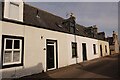
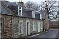
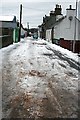
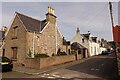
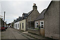
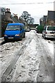
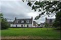
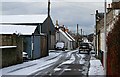
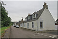
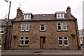
Please click the More button for more images, licensing and image copyright information.
Member of UK Parliament
This postcode is in the Moray parliamentary constituency.
Moray is a constituency in Scotland. The seat has been held by Douglas Ross (Conservative) since June 2017.

Most Recent House Sales for Maxwell Street, IV32 7DE
No recorded house sales or transfers for this postcode.
Local Petrol Station Prices
Coordinates for IV32 7DE
Sunrise and Sunset at IV32 7DE
Traffic Emission and Congestion Zones
Historical Weather Summary
| Clear | 10.14% |
| Cloudy | 57.50% |
| Rain | 5.23% |
| Windy | 26.05% |
| Other | 1.08% |
Average Energy Performance
Companies Registered at IV32 7DE
Postcode Details for IV32 7DE
Recent Updates
|
18 Apr 2024 Added Traffic Camera Views from Traffic Scotland to Roadworks within Scotland |
|
15 Apr 2024 Schools Data updated for April 2024 |
|
10 Apr 2024 Companies Data updated for March 2024 |
|
7 Apr 2024 New option to receive automatic updates to roadworks that affect you |
|
7 Apr 2024 Police and Crime data updated for February 2024 |
|
3 Apr 2024 Sold House Price data updated for February 2024 |
|
30 Mar 2024 Energy Performance Certificates (England and Wales) updated February 2024 |
|
28 Mar 2024 New feature to use Geolocating functions to detect your current location |
Random Postcodes
Want an idea of what is in our extensive website? Try somewhere completely random!
The Rural/Urban classification is based upon data collected during the 2011 Census and released in August 2013 and is categorised into 6 distinct classes.
[A] Urban Major conurbation: A built up area with a population of 10,000 (3,000 in Scotland) or more and is assigned to the major conurbation settlement category.
[B] Urban Minor conurbation: A built up area with a population of 10,000 (3,000 in Scotland) or more and is assigned to the minor conurbation settlement category.
[C] Urban City and town: A built up area with a population of 10,000 (3,000 in Scotland) or more and is assigned to the city and town settlement category.
[D] Rural Town and fringe
[E] Rural Village
[F] Rural Hamlet and isolated dwelling
The Index of Multiple Deprivation (IMD) is the official measure of relative deprivation.
The index is based on 39 separate indicators across seven distinct domains (Income; Employment; Health and Disability; Education, Skills and Training; Crime; Barriers to Housing and Services; Living Environment) to provide an overall measure of multiple deprivation and is calculated for every neighbourhood.
The index is relative rather than an absolute scale and so a neighbourhood with a score of 10 is more deprived than one rated 20, but this does not equate to being twice as deprived.
Please note: Different indices are used in England, Scotland, Wales and Northern Ireland and so comparison of scores from neighbourhoods in different countries should not be undertaken.
These figures report on incorporated UK companies only that are registered at this postcode and do not include sole-traders, partnerships or overseas organisations.
The population figure shown for your area are an estimate provided by the Office for National Statistics and is rounded to the nearest 1,000.
The estimates are derived from the Annual Population Survey (APS) which is the Labour Force Survey (LFS) plus various sample boosts.
There are 55 unitary authorities. They provide all local government services in their areas. These are mainly in the cities, urban areas and larger towns although there are now 6 shire county councils that are unitary (ie have no district councils beneath them).