Overview for Marine Court, LOSSIEMOUTH, IV31 6SR
Introduction
Lossiemouth is a town in Moray, Scotland. Originally the port belonging to Elgin, it became an important fishing town. Although there has been over 1,000 years of settlement in the area, the present day town was formed over the past 250 years and consists of four separate communities that eventually merged into one. From 1890 to 1975, it was a police burgh as Lossiemouth and Branderburgh.
Stotfield, the first significant settlement (discounting Kinneddar which has now disappeared), lies to the north west of the town. Next was the Seatown – a small area between the river and the canal inholding of 52 houses, 51 of which are the historic fisher cottages. When the new harbour was built on the River Lossie, the 18th-century planned town of Lossiemouth, built on a grid system, was established on the low ground below the Coulard Hill. Branderburgh formed the final development during the 19th century. This part of the town developed entirely as a result of the new harbour with its two basins, and eventually covered the entire Coulard Hill; it has an impressive profile when seen from a distance.
Summary for Marine Court, LOSSIEMOUTH, IV31 6SR
Roadworks near IV31 6SR
Road Safety near IV31 6SR
Details of personal injury accidents in and around Marine Court, IV31 6SR that have been reported to over the past 20 years.
Traffic Levels near IV31 6SR
View traffic levels near Marine Court, IV31 6SR from official Department for Transport counts.
Images taken near to Marine Court, IV31 6SR and the surrounding area
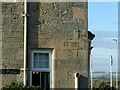


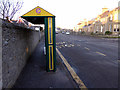
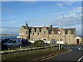


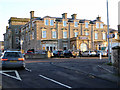
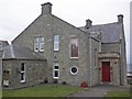
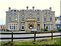
Please click the More button for more images, licensing and image copyright information.
Member of UK Parliament
This postcode is in the Moray parliamentary constituency.
Moray is a constituency in Scotland. The seat has been held by Douglas Ross (Conservative) since June 2017.

Most Recent House Sales for Marine Court, IV31 6SR
No recorded house sales or transfers for this postcode.
Local Petrol Station Prices
Coordinates for IV31 6SR
Sunrise and Sunset at IV31 6SR
Traffic Emission and Congestion Zones
Historical Weather Summary
| Clear | 10.51% |
| Cloudy | 47.12% |
| Rain | 6.06% |
| Windy | 35.94% |
| Other | 0.37% |
Average Energy Performance
Companies Registered at IV31 6SR
Postcode Details for IV31 6SR
Recent Updates
|
18 Apr 2024 Added Traffic Camera Views from Traffic Scotland to Roadworks within Scotland |
|
15 Apr 2024 Schools Data updated for April 2024 |
|
10 Apr 2024 Companies Data updated for March 2024 |
|
7 Apr 2024 New option to receive automatic updates to roadworks that affect you |
|
7 Apr 2024 Police and Crime data updated for February 2024 |
|
3 Apr 2024 Sold House Price data updated for February 2024 |
|
30 Mar 2024 Energy Performance Certificates (England and Wales) updated February 2024 |
|
28 Mar 2024 New feature to use Geolocating functions to detect your current location |
Random Postcodes
Want an idea of what is in our extensive website? Try somewhere completely random!
The Rural/Urban classification is based upon data collected during the 2011 Census and released in August 2013 and is categorised into 6 distinct classes.
[A] Urban Major conurbation: A built up area with a population of 10,000 (3,000 in Scotland) or more and is assigned to the major conurbation settlement category.
[B] Urban Minor conurbation: A built up area with a population of 10,000 (3,000 in Scotland) or more and is assigned to the minor conurbation settlement category.
[C] Urban City and town: A built up area with a population of 10,000 (3,000 in Scotland) or more and is assigned to the city and town settlement category.
[D] Rural Town and fringe
[E] Rural Village
[F] Rural Hamlet and isolated dwelling
The Index of Multiple Deprivation (IMD) is the official measure of relative deprivation.
The index is based on 39 separate indicators across seven distinct domains (Income; Employment; Health and Disability; Education, Skills and Training; Crime; Barriers to Housing and Services; Living Environment) to provide an overall measure of multiple deprivation and is calculated for every neighbourhood.
The index is relative rather than an absolute scale and so a neighbourhood with a score of 10 is more deprived than one rated 20, but this does not equate to being twice as deprived.
Please note: Different indices are used in England, Scotland, Wales and Northern Ireland and so comparison of scores from neighbourhoods in different countries should not be undertaken.
These figures report on incorporated UK companies only that are registered at this postcode and do not include sole-traders, partnerships or overseas organisations.
The population figure shown for your area are an estimate provided by the Office for National Statistics and is rounded to the nearest 1,000.
The estimates are derived from the Annual Population Survey (APS) which is the Labour Force Survey (LFS) plus various sample boosts.
There are 55 unitary authorities. They provide all local government services in their areas. These are mainly in the cities, urban areas and larger towns although there are now 6 shire county councils that are unitary (ie have no district councils beneath them).