Overview for North Tolsta, ISLE OF LEWIS, HS2 0NQ
Introduction
The Isle of Lewis or simply Lewis is the northern part of Lewis and Harris, the largest island of the Western Isles or Outer Hebrides archipelago in Scotland. The two parts are frequently referred to as if they were separate islands. The total area of Lewis is 683 square miles (1,770 km2).
Lewis is, in general, the lower-lying part of the island: the other part, Harris, is more mountainous. Due to its larger area and flatter, more fertile land, Lewis contains three-quarters of the population of the Western Isles, and the largest settlement, Stornoway. The island's diverse habitats are home to an assortment of flora and fauna, such as the golden eagle, red deer and seal, and are recognised in a number of conservation areas.
Lewis has a Presbyterian tradition and a rich history. It was once part of the Norse Kingdom of the Isles. Today, life is very different from elsewhere in Scotland, with Sabbath observance, the Scottish Gaelic language and peat cutting retaining more importance than elsewhere. Lewis has a rich cultural heritage as can be seen from its myths and legends as well as the local literary and musical traditions.
Summary for North Tolsta, ISLE OF LEWIS, HS2 0NQ
Roadworks near HS2 0NQ
Road Safety near HS2 0NQ
Details of personal injury accidents in and around HS2 0NQ that have been reported to over the past 20 years.
Traffic Levels near HS2 0NQ
View traffic levels near HS2 0NQ from official Department for Transport counts.
Images taken in and around the hs20nq area
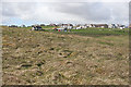
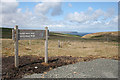
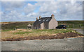

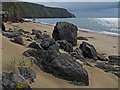
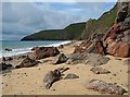
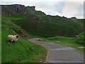
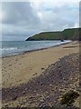
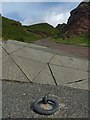
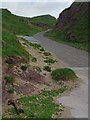
Please click the More button for more images, licensing and image copyright information.
Member of UK Parliament
This postcode is in the Na h-Eileanan an Iar parliamentary constituency.
Na h-Eileanan an Iar is a constituency in Scotland. The seat has been held by Angus Brendan MacNeil (Independent) since May 2005.

Most Recent House Sales for HS2 0NQ
No recorded house sales or transfers for this postcode.
Local Petrol Station Prices
Coordinates for HS2 0NQ
Sunrise and Sunset at HS2 0NQ
Traffic Emission and Congestion Zones
Historical Weather Summary
| Clear | 6.42% |
| Cloudy | 26.30% |
| Rain | 11.22% |
| Windy | 55.97% |
| Other | 0.09% |
Average Energy Performance
Companies Registered at HS2 0NQ
Postcode Details for HS2 0NQ
Recent Updates
|
18 Apr 2024 Added Traffic Camera Views from Traffic Scotland to Roadworks within Scotland |
|
15 Apr 2024 Schools Data updated for April 2024 |
|
10 Apr 2024 Companies Data updated for March 2024 |
|
7 Apr 2024 New option to receive automatic updates to roadworks that affect you |
|
7 Apr 2024 Police and Crime data updated for February 2024 |
|
3 Apr 2024 Sold House Price data updated for February 2024 |
|
30 Mar 2024 Energy Performance Certificates (England and Wales) updated February 2024 |
|
28 Mar 2024 New feature to use Geolocating functions to detect your current location |
Random Postcodes
Want an idea of what is in our extensive website? Try somewhere completely random!
The Rural/Urban classification is based upon data collected during the 2011 Census and released in August 2013 and is categorised into 6 distinct classes.
[A] Urban Major conurbation: A built up area with a population of 10,000 (3,000 in Scotland) or more and is assigned to the major conurbation settlement category.
[B] Urban Minor conurbation: A built up area with a population of 10,000 (3,000 in Scotland) or more and is assigned to the minor conurbation settlement category.
[C] Urban City and town: A built up area with a population of 10,000 (3,000 in Scotland) or more and is assigned to the city and town settlement category.
[D] Rural Town and fringe
[E] Rural Village
[F] Rural Hamlet and isolated dwelling
The Index of Multiple Deprivation (IMD) is the official measure of relative deprivation.
The index is based on 39 separate indicators across seven distinct domains (Income; Employment; Health and Disability; Education, Skills and Training; Crime; Barriers to Housing and Services; Living Environment) to provide an overall measure of multiple deprivation and is calculated for every neighbourhood.
The index is relative rather than an absolute scale and so a neighbourhood with a score of 10 is more deprived than one rated 20, but this does not equate to being twice as deprived.
Please note: Different indices are used in England, Scotland, Wales and Northern Ireland and so comparison of scores from neighbourhoods in different countries should not be undertaken.
These figures report on incorporated UK companies only that are registered at this postcode and do not include sole-traders, partnerships or overseas organisations.
The population figure shown for your area are an estimate provided by the Office for National Statistics and is rounded to the nearest 1,000.
The estimates are derived from the Annual Population Survey (APS) which is the Labour Force Survey (LFS) plus various sample boosts.
There are 55 unitary authorities. They provide all local government services in their areas. These are mainly in the cities, urban areas and larger towns although there are now 6 shire county councils that are unitary (ie have no district councils beneath them).