Overview for Dalston Gardens, STANMORE, HA7 1DA
Introduction
Stanmore is part of the London Borough of Harrow in Greater London. It is centred 11 miles (18 km) northwest of Charing Cross, lies on the outskirts of the London urban area and includes Stanmore Hill, one of the highest points of London, at 152 metres (499 ft) high. The district, which developed from the ancient Middlesex parishes of Great and Little Stanmore, lies immediately west of Roman Watling Street (the A5 road) and forms the eastern part of the modern London Borough of Harrow.
Stanmore is the location of the former RAF Bentley Priory station – base of the Fighter Command during both world wars – along with its accommodating Bentley Priory mansion, notably the last residence of Queen Adelaide. Some members of the Bernays family were also based here, including Adolphus Bernays and his son and grandson who were both rectors of St John's church; the Bernays Institute and Bernays Gardens are public amenities in the centre of the old village.
The district increasingly developed into a London suburb during the 20th century, and in the latter half housed the Automobile Association's regional headquarters. Today it is a commuter town with a local tube station that is the northern terminus of the Jubilee line, and large green spaces.
Summary for Dalston Gardens, STANMORE, HA7 1DA
Roadworks near HA7 1DA
Road Safety near HA7 1DA
Details of personal injury accidents in and around Dalston Gardens, HA7 1DA that have been reported to Metropolitan Police Service over the past 20 years.
Traffic Levels near HA7 1DA
View traffic levels near Dalston Gardens, HA7 1DA from official Department for Transport counts.
Images taken near to Dalston Gardens, HA7 1DA and the surrounding area
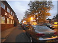
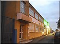

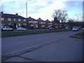


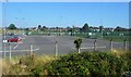
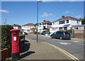

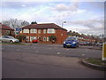
Please click the More button for more images, licensing and image copyright information.
Member of UK Parliament
This postcode is in the Harrow East parliamentary constituency.
Harrow East is a constituency in London, England. The seat has been held by Bob Blackman (Conservative) since May 2010.

Most Recent House Sales for Dalston Gardens, HA7 1DA
21 Jun 2023
13 Dec 2022
31 Oct 2022
24 Sep 2021
Local Petrol Station Prices
Coordinates for HA7 1DA
Residents at HA7 1DA
Sunrise and Sunset at HA7 1DA
Traffic Emission Zones
Historical Weather Summary
| Clear | 9.15% |
| Cloudy | 80.07% |
| Rain | 8.51% |
| Windy | 2.22% |
| Other | 0.05% |
Population
Deprivation Index
the more deprived the postcode
Average Energy Performance
Companies Registered at HA7 1DA
Postcode Details for HA7 1DA
Recent Updates
|
18 Apr 2024 Added Traffic Camera Views from Traffic Scotland to Roadworks within Scotland |
|
15 Apr 2024 Schools Data updated for April 2024 |
|
10 Apr 2024 Companies Data updated for March 2024 |
|
7 Apr 2024 New option to receive automatic updates to roadworks that affect you |
|
7 Apr 2024 Police and Crime data updated for February 2024 |
|
3 Apr 2024 Sold House Price data updated for February 2024 |
|
30 Mar 2024 Energy Performance Certificates (England and Wales) updated February 2024 |
|
28 Mar 2024 New feature to use Geolocating functions to detect your current location |
Random Postcodes
Want an idea of what is in our extensive website? Try somewhere completely random!
The Rural/Urban classification is based upon data collected during the 2011 Census and released in August 2013 and is categorised into 6 distinct classes.
[A] Urban Major conurbation: A built up area with a population of 10,000 (3,000 in Scotland) or more and is assigned to the major conurbation settlement category.
[B] Urban Minor conurbation: A built up area with a population of 10,000 (3,000 in Scotland) or more and is assigned to the minor conurbation settlement category.
[C] Urban City and town: A built up area with a population of 10,000 (3,000 in Scotland) or more and is assigned to the city and town settlement category.
[D] Rural Town and fringe
[E] Rural Village
[F] Rural Hamlet and isolated dwelling
The Index of Multiple Deprivation (IMD) is the official measure of relative deprivation.
The index is based on 39 separate indicators across seven distinct domains (Income; Employment; Health and Disability; Education, Skills and Training; Crime; Barriers to Housing and Services; Living Environment) to provide an overall measure of multiple deprivation and is calculated for every neighbourhood.
The index is relative rather than an absolute scale and so a neighbourhood with a score of 10 is more deprived than one rated 20, but this does not equate to being twice as deprived.
Please note: Different indices are used in England, Scotland, Wales and Northern Ireland and so comparison of scores from neighbourhoods in different countries should not be undertaken.
These figures report on incorporated UK companies only that are registered at this postcode and do not include sole-traders, partnerships or overseas organisations.
The population figure shown for your area are an estimate provided by the Office for National Statistics and is rounded to the nearest 1,000.
The estimates are derived from the Annual Population Survey (APS) which is the Labour Force Survey (LFS) plus various sample boosts.
There are 32 London boroughs. They provide nearly all the services in their area. However, the Greater London Authority (GLA) provides London-wide government, including special responsibility for police, fire, strategic planning and transport.