Overview for The Borough, FARNHAM, GU9 7NF
Introduction
Farnham is a market town and civil parish in Surrey, England, around 36 miles (58 km) southwest of London. It is in the Borough of Waverley, close to the county border with Hampshire. The town is on the north branch of the River Wey, a tributary of the Thames, and is at the western end of the North Downs. The civil parish, which includes the villages of Badshot Lea, Hale and Wrecclesham, covers 14.1 sq mi (37 km2) and had a population of 39,488 in 2011.
Among the prehistoric objects from the area is a woolly mammoth tusk, excavated in Badshot Lea at the start of the 21st century. The earliest evidence of human activity is from the Neolithic and, during the Roman period, tile making took place close to the town centre. The name "Farnham" is of Saxon origin and is generally agreed to mean "meadow where ferns grow". From at least 803, the settlement was under the control of the Bishops of Winchester and the castle was built as a residence for Bishop Henry de Blois in 1138. Henry VIII is thought to have spent part of his childhood under the care of Bishop Richard Foxe and is known to have lived at Farnham Castle when he was 16.
In the late medieval period, the primary local industry was the production of kersey, a coarse, woollen cloth. In the early modern period, the town's weekly corn market was said to the second largest in England after London. Between 1600 and the 1970s, the area was a centre for growing hops and for the brewing industry. The town began to expand in the early Victorian period, stimulated in part by the opening of the railway in 1849 and the arrival of the army in nearby Aldershot in 1855. Farnham became an Urban District in 1894, but under the Local Government Act 1972, its status was reduced to a civil parish with a town council.
The Farnham area has long been associated with the creative arts and with pottery making in particular. One of four campuses of the University for the Creative Arts is to the west of the centre and there are numerous works of public art on display in the town. Notable buildings in the civil parish include the ruins of Waverley Abbey and the 18th century Willmer House, now the location of the Museum of Farnham. Politician William Cobbett and writer George Sturt were both born in Farnham, as was Maud Gonne, the Irish republican suffragette. More recent residents have included the watercolour artist, William Herbert Allen, the Formula One driver, Mike Hawthorn, the England cricketer, Graham Thorpe, and the England rugby union captain, Jonny Wilkinson.
Summary for The Borough, FARNHAM, GU9 7NF
Roadworks near GU9 7NF
Road Safety near GU9 7NF
Details of personal injury accidents in and around The Borough, GU9 7NF that have been reported to Surrey Police over the past 20 years.
Traffic Levels near GU9 7NF
View traffic levels near The Borough, GU9 7NF from official Department for Transport counts.
Images taken near to The Borough, GU9 7NF and the surrounding area
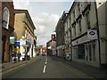
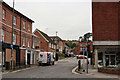
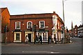
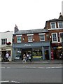
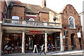
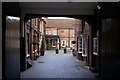

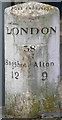
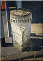
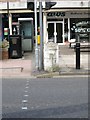
Please click the More button for more images, licensing and image copyright information.
Member of UK Parliament
This postcode is in the South West Surrey parliamentary constituency.
South West Surrey is a constituency in the South East region of England. The seat has been held by Jeremy Hunt (Conservative) since May 2010.

Most Recent House Sales for The Borough, GU9 7NF
No recorded house sales or transfers for this postcode.
Local Petrol Station Prices
Coordinates for GU9 7NF
Residents at GU9 7NF
Sunrise and Sunset at GU9 7NF
Traffic Emission and Congestion Zones
Historical Weather Summary
| Clear | 22.25% |
| Cloudy | 67.33% |
| Rain | 7.04% |
| Windy | 3.15% |
| Other | 0.23% |
Population
Deprivation Index
the more deprived the postcode
Companies Registered at GU9 7NF
Postcode Details for GU9 7NF
Recent Updates
|
15 Apr 2024 Schools Data updated for April 2024 |
|
10 Apr 2024 Companies Data updated for March 2024 |
|
7 Apr 2024 New option to receive automatic updates to roadworks that affect you |
|
7 Apr 2024 Police and Crime data updated for February 2024 |
|
3 Apr 2024 Sold House Price data updated for February 2024 |
|
30 Mar 2024 Energy Performance Certificates (England and Wales) updated February 2024 |
|
28 Mar 2024 New feature to use Geolocating functions to detect your current location |
|
17 Mar 2024 Schools Data updated for March 2024 |
Random Postcodes
Want an idea of what is in our extensive website? Try somewhere completely random!
The Rural/Urban classification is based upon data collected during the 2011 Census and released in August 2013 and is categorised into 6 distinct classes.
[A] Urban Major conurbation: A built up area with a population of 10,000 (3,000 in Scotland) or more and is assigned to the major conurbation settlement category.
[B] Urban Minor conurbation: A built up area with a population of 10,000 (3,000 in Scotland) or more and is assigned to the minor conurbation settlement category.
[C] Urban City and town: A built up area with a population of 10,000 (3,000 in Scotland) or more and is assigned to the city and town settlement category.
[D] Rural Town and fringe
[E] Rural Village
[F] Rural Hamlet and isolated dwelling
The Index of Multiple Deprivation (IMD) is the official measure of relative deprivation.
The index is based on 39 separate indicators across seven distinct domains (Income; Employment; Health and Disability; Education, Skills and Training; Crime; Barriers to Housing and Services; Living Environment) to provide an overall measure of multiple deprivation and is calculated for every neighbourhood.
The index is relative rather than an absolute scale and so a neighbourhood with a score of 10 is more deprived than one rated 20, but this does not equate to being twice as deprived.
Please note: Different indices are used in England, Scotland, Wales and Northern Ireland and so comparison of scores from neighbourhoods in different countries should not be undertaken.
These figures report on incorporated UK companies only that are registered at this postcode and do not include sole-traders, partnerships or overseas organisations.
The population figure shown for your area are an estimate provided by the Office for National Statistics and is rounded to the nearest 1,000.
The estimates are derived from the Annual Population Survey (APS) which is the Labour Force Survey (LFS) plus various sample boosts.
There are 26 county councils in 2-tier areas, providing services such as education, social services and waste disposal.
In 2-tier areas, each county council area is subdivided into districts, for which there is an independent district council. There are 192 district councils.
District councils are responsible for local services such as rubbish collection, housing and planning applications.