Overview for Ganvaghan Road, CASTLEDERG, BT81 7SY
Introduction
Castlederg is a town in County Tyrone, Northern Ireland. It lies on the River Derg and is near the border with County Donegal, Ireland. It stands in the townlands of Castlesessagh and Churchtown, in the historic barony of Omagh West and the civil parish of Urney. The village has a ruined castle and two ancient tombs known as the Druid's Altar and Todd's Den. It had a population of 2,980 people at the 2021 Census.
The village hosts some of the district's key events each year, including the Derg Vintage Rally, Dergfest music festival, Red River Festival and the traditional Apple Fair.
Castlederg was a traveller's stop along the ancient pilgrimage route to Station Island on Lough Derg. The town boasts ancient ruins and monastic settlements.
Summary for Ganvaghan Road, CASTLEDERG, BT81 7SY
Roadworks near BT81 7SY
Local roadworks in Northern Ireland are provided by Traffic Watch NI on their website at trafficwatchni.com/twni/traffic-news.
Unfortunately, whilst the information is provided, the orgasation do not provide location coordinates and so we are unable to map the planned works to local postcodes at this time.
Road Safety near BT81 7SY
Details of personal injury accidents in and around Ganvaghan Road, BT81 7SY that have been reported to Police Service of Northern Ireland over the past 20 years.
Traffic Levels near BT81 7SY
View traffic levels near Ganvaghan Road, BT81 7SY from official Department for Transport counts.
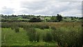
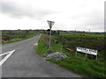
Images taken near to Ganvaghan Road, BT81 7SY and the surrounding area
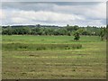
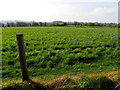
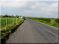
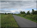
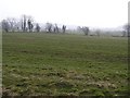
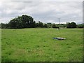
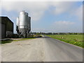
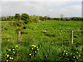
Please click the More button for more images, licensing and image copyright information.
Police
This area is policed by Police Service of Northern Ireland.
Police Service of Northern Ireland split their policing area into 26 separate neighbourhoods and this postcode is in the Strabane neighbourhood.

Strabane Neighbourhood Crime
Top 3 Categories
For full details of all categories together with more crime information, click on the Details button.
Member of UK Parliament
Unfortunately, Parliamentary details are not available for this postcode.
Most Recent House Sales for Ganvaghan Road, BT81 7SY
No recorded house sales or transfers for this postcode.
Local Petrol Station Prices
Coordinates for BT81 7SY
Sunrise and Sunset at BT81 7SY
Traffic Emission and Congestion Zones
Historical Weather Summary
| Clear | 5.62% |
| Cloudy | 63.74% |
| Rain | 10.89% |
| Windy | 19.53% |
| Other | 0.22% |
Companies Registered at BT81 7SY
Postcode Details for BT81 7SY
Recent Updates
|
18 Apr 2024 Added Traffic Camera Views from Traffic Scotland to Roadworks within Scotland |
|
15 Apr 2024 Schools Data updated for April 2024 |
|
10 Apr 2024 Companies Data updated for March 2024 |
|
7 Apr 2024 New option to receive automatic updates to roadworks that affect you |
|
7 Apr 2024 Police and Crime data updated for February 2024 |
|
3 Apr 2024 Sold House Price data updated for February 2024 |
|
30 Mar 2024 Energy Performance Certificates (England and Wales) updated February 2024 |
|
28 Mar 2024 New feature to use Geolocating functions to detect your current location |
Random Postcodes
Want an idea of what is in our extensive website? Try somewhere completely random!
The Rural/Urban classification is based upon data collected during the 2011 Census and released in August 2013 and is categorised into 6 distinct classes.
[A] Urban Major conurbation: A built up area with a population of 10,000 (3,000 in Scotland) or more and is assigned to the major conurbation settlement category.
[B] Urban Minor conurbation: A built up area with a population of 10,000 (3,000 in Scotland) or more and is assigned to the minor conurbation settlement category.
[C] Urban City and town: A built up area with a population of 10,000 (3,000 in Scotland) or more and is assigned to the city and town settlement category.
[D] Rural Town and fringe
[E] Rural Village
[F] Rural Hamlet and isolated dwelling
The Index of Multiple Deprivation (IMD) is the official measure of relative deprivation.
The index is based on 39 separate indicators across seven distinct domains (Income; Employment; Health and Disability; Education, Skills and Training; Crime; Barriers to Housing and Services; Living Environment) to provide an overall measure of multiple deprivation and is calculated for every neighbourhood.
The index is relative rather than an absolute scale and so a neighbourhood with a score of 10 is more deprived than one rated 20, but this does not equate to being twice as deprived.
Please note: Different indices are used in England, Scotland, Wales and Northern Ireland and so comparison of scores from neighbourhoods in different countries should not be undertaken.
These figures report on incorporated UK companies only that are registered at this postcode and do not include sole-traders, partnerships or overseas organisations.
The population figure shown for your area are an estimate provided by the Office for National Statistics and is rounded to the nearest 1,000.
The estimates are derived from the Annual Population Survey (APS) which is the Labour Force Survey (LFS) plus various sample boosts.
There are 26 county councils in 2-tier areas, providing services such as education, social services and waste disposal.
In 2-tier areas, each county council area is subdivided into districts, for which there is an independent district council. There are 192 district councils.
District councils are responsible for local services such as rubbish collection, housing and planning applications.