Overview for Lichfield Street, TAMWORTH, B78 3QN
Introduction
Tamworth is a market town and borough in Staffordshire, England, 14 miles (23 km) north-east of Birmingham. The town borders North Warwickshire to the east and north, Lichfield to the north, south-west and west. The town takes its name from the River Tame, which flows through it. The population of Tamworth borough (2021) was 78,646. The wider urban area had a population of 81,964.
Tamworth was the principal centre of royal power of the Anglo-Saxon Kingdom of Mercia during the 8th and 9th centuries. It hosts a simple but elevated 12th century castle, a well-preserved medieval church (the Church of St Editha) and a Moat House. Tamworth was historically divided between Warwickshire and Staffordshire until 1889, when the town was placed entirely in Staffordshire.
The town's industries include logistics, engineering, clothing, brick, tile and paper manufacture. Until 2001 one of its factories was Reliant, which produced the Reliant Robin three-wheeler car and the Reliant Scimitar sports car.
The Snowdome, a prototype real-snow indoor ski slope is in Tamworth and 1.7 miles (2.7 km) south is Drayton Manor Theme Park and one of the many marinas serving the Coventry Canal and Birmingham and Fazeley Canal which combine south of the town.
Summary for Lichfield Street, TAMWORTH, B78 3QN
Roadworks near B78 3QN
Road Safety near B78 3QN
Details of personal injury accidents in and around Lichfield Street, B78 3QN that have been reported to Staffordshire Police over the past 20 years.
Traffic Levels near B78 3QN
View traffic levels near Lichfield Street, B78 3QN from official Department for Transport counts.
Images taken near to Lichfield Street, B78 3QN and the surrounding area
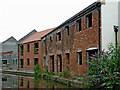
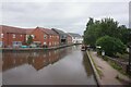
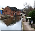
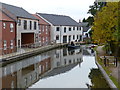
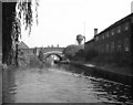
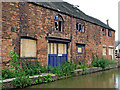
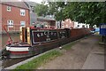
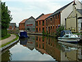
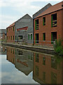
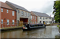
Please click the More button for more images, licensing and image copyright information.
Tamworth and nearby Videos From YouTube
Tamworth in the Autumn - A short drone film shot on the DJI Mini 2
A short cinematic style film shot in the autumn using the DJI Mini 2 drone. For any enquiries please contact ...
Channel: Frankie A (View Channel)
Published: 16 Jun 2022
Police
This area is policed by Staffordshire Police.
Staffordshire Police split their policing area into 97 separate neighbourhoods and this postcode is in the Bourne Vale and Fazeley neighbourhood.

Bourne Vale and Fazeley Neighbourhood Crime
Top 3 Categories
For full details of all categories together with more crime information, click on the Details button.
Member of UK Parliament
This postcode is in the Tamworth parliamentary constituency.
Tamworth is a constituency in the West Midlands region of England. The seat has been held by Sarah Edwards (Labour) since October 2023.

Most Recent House Sales for Lichfield Street, B78 3QN
11 Mar 2020
16 Mar 2016
28 Mar 2013
22 May 2007
Local Petrol Station Prices
Coordinates for B78 3QN
Residents at B78 3QN
Sunrise and Sunset at B78 3QN
Traffic Emission and Congestion Zones
Historical Weather Summary
| Clear | 20.98% |
| Cloudy | 69.82% |
| Rain | 6.39% |
| Windy | 2.74% |
| Other | 0.07% |
Population
Deprivation Index
the more deprived the postcode
Average Energy Performance
Companies Registered at B78 3QN
Postcode Details for B78 3QN
Recent Updates
|
18 Apr 2024 Added Traffic Camera Views from Traffic Scotland to Roadworks within Scotland |
|
15 Apr 2024 Schools Data updated for April 2024 |
|
10 Apr 2024 Companies Data updated for March 2024 |
|
7 Apr 2024 New option to receive automatic updates to roadworks that affect you |
|
7 Apr 2024 Police and Crime data updated for February 2024 |
|
3 Apr 2024 Sold House Price data updated for February 2024 |
|
30 Mar 2024 Energy Performance Certificates (England and Wales) updated February 2024 |
|
28 Mar 2024 New feature to use Geolocating functions to detect your current location |
Random Postcodes
Want an idea of what is in our extensive website? Try somewhere completely random!
The Rural/Urban classification is based upon data collected during the 2011 Census and released in August 2013 and is categorised into 6 distinct classes.
[A] Urban Major conurbation: A built up area with a population of 10,000 (3,000 in Scotland) or more and is assigned to the major conurbation settlement category.
[B] Urban Minor conurbation: A built up area with a population of 10,000 (3,000 in Scotland) or more and is assigned to the minor conurbation settlement category.
[C] Urban City and town: A built up area with a population of 10,000 (3,000 in Scotland) or more and is assigned to the city and town settlement category.
[D] Rural Town and fringe
[E] Rural Village
[F] Rural Hamlet and isolated dwelling
The Index of Multiple Deprivation (IMD) is the official measure of relative deprivation.
The index is based on 39 separate indicators across seven distinct domains (Income; Employment; Health and Disability; Education, Skills and Training; Crime; Barriers to Housing and Services; Living Environment) to provide an overall measure of multiple deprivation and is calculated for every neighbourhood.
The index is relative rather than an absolute scale and so a neighbourhood with a score of 10 is more deprived than one rated 20, but this does not equate to being twice as deprived.
Please note: Different indices are used in England, Scotland, Wales and Northern Ireland and so comparison of scores from neighbourhoods in different countries should not be undertaken.
These figures report on incorporated UK companies only that are registered at this postcode and do not include sole-traders, partnerships or overseas organisations.
The population figure shown for your area are an estimate provided by the Office for National Statistics and is rounded to the nearest 1,000.
The estimates are derived from the Annual Population Survey (APS) which is the Labour Force Survey (LFS) plus various sample boosts.
There are 26 county councils in 2-tier areas, providing services such as education, social services and waste disposal.
In 2-tier areas, each county council area is subdivided into districts, for which there is an independent district council. There are 192 district councils.
District councils are responsible for local services such as rubbish collection, housing and planning applications.