Overview for Bank Square, DULVERTON, TA22 9BU
Introduction
Dulverton is a small town and civil parish in west Somerset, England, near the border with Devon. The town had a population of 1,408 at the 2011 Census. The parish includes the hamlets of Battleton and Ashwick which is located approximately 3.5 miles (5.6 km) north west of Dulverton. To the west of the hamlet lies Ashwick House, built in the Edwardian style in 1901. Also nearby is the estate of Northmoor, formerly a seat of Sir Frederick Wills, 1st Baronet of Northmoor, one of the four Wills Baronetcys, and the founders of the Imperial Tobacco Company. In 1929 Sir Frederick's son & heir, Sir Gilbert Wills, 2nd Baronet, was raised to the peerage as Baron Dulverton, whose principal seat was at Batsford Park, near Batsford, Gloucestershire.
Dulverton is a popular tourist destination for exploring Exmoor, and is home to the Exmoor National Park Authority headquarters. The town lies on the route of the Exe Valley Way and Land's End Trail.
Summary for Bank Square, DULVERTON, TA22 9BU
Roadworks near TA22 9BU
Road Safety near TA22 9BU
Details of personal injury accidents in and around Bank Square, TA22 9BU that have been reported to Avon and Somerset Constabulary over the past 20 years.
Traffic Levels near TA22 9BU
View traffic levels near Bank Square, TA22 9BU from official Department for Transport counts.
Images taken near to Bank Square, TA22 9BU and the surrounding area

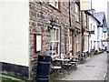
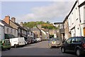
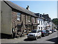
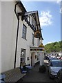
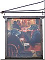

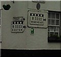

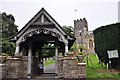
Please click the More button for more images, licensing and image copyright information.
Police
This area is policed by Avon and Somerset Constabulary.
Avon and Somerset Constabulary split their policing area into 123 separate neighbourhoods and this postcode is in the Exmoor neighbourhood.

Exmoor Neighbourhood Crime
Top 3 Categories
For full details of all categories together with more crime information, click on the Details button.
Member of UK Parliament
This postcode is in the Bridgwater and West Somerset parliamentary constituency.
Bridgwater and West Somerset is a constituency in the South West region of England. The seat has been held by Mr Ian Liddell-Grainger (Conservative) since May 2010.

Most Recent House Sales for Bank Square, TA22 9BU
12 Dec 2023
20 Mar 2015
9 Aug 2007
5 Jan 2007
Local Petrol Station Prices
Coordinates for TA22 9BU
Residents at TA22 9BU
Sunrise and Sunset at TA22 9BU
Traffic Emission and Congestion Zones
Historical Weather Summary
| Clear | 19.96% |
| Cloudy | 64.65% |
| Rain | 8.26% |
| Windy | 6.63% |
| Other | 0.50% |
Deprivation Index
the more deprived the postcode
Average Energy Performance
Companies Registered at TA22 9BU
National Park for TA22 9BU
Postcode Details for TA22 9BU
Recent Updates
|
18 Apr 2024 Added Traffic Camera Views from Traffic Scotland to Roadworks within Scotland |
|
15 Apr 2024 Schools Data updated for April 2024 |
|
10 Apr 2024 Companies Data updated for March 2024 |
|
7 Apr 2024 New option to receive automatic updates to roadworks that affect you |
|
7 Apr 2024 Police and Crime data updated for February 2024 |
|
3 Apr 2024 Sold House Price data updated for February 2024 |
|
30 Mar 2024 Energy Performance Certificates (England and Wales) updated February 2024 |
|
28 Mar 2024 New feature to use Geolocating functions to detect your current location |
Random Postcodes
Want an idea of what is in our extensive website? Try somewhere completely random!
The Rural/Urban classification is based upon data collected during the 2011 Census and released in August 2013 and is categorised into 6 distinct classes.
[A] Urban Major conurbation: A built up area with a population of 10,000 (3,000 in Scotland) or more and is assigned to the major conurbation settlement category.
[B] Urban Minor conurbation: A built up area with a population of 10,000 (3,000 in Scotland) or more and is assigned to the minor conurbation settlement category.
[C] Urban City and town: A built up area with a population of 10,000 (3,000 in Scotland) or more and is assigned to the city and town settlement category.
[D] Rural Town and fringe
[E] Rural Village
[F] Rural Hamlet and isolated dwelling
The Index of Multiple Deprivation (IMD) is the official measure of relative deprivation.
The index is based on 39 separate indicators across seven distinct domains (Income; Employment; Health and Disability; Education, Skills and Training; Crime; Barriers to Housing and Services; Living Environment) to provide an overall measure of multiple deprivation and is calculated for every neighbourhood.
The index is relative rather than an absolute scale and so a neighbourhood with a score of 10 is more deprived than one rated 20, but this does not equate to being twice as deprived.
Please note: Different indices are used in England, Scotland, Wales and Northern Ireland and so comparison of scores from neighbourhoods in different countries should not be undertaken.
These figures report on incorporated UK companies only that are registered at this postcode and do not include sole-traders, partnerships or overseas organisations.
The population figure shown for your area are an estimate provided by the Office for National Statistics and is rounded to the nearest 1,000.
The estimates are derived from the Annual Population Survey (APS) which is the Labour Force Survey (LFS) plus various sample boosts.
There are 55 unitary authorities. They provide all local government services in their areas. These are mainly in the cities, urban areas and larger towns although there are now 6 shire county councils that are unitary (ie have no district councils beneath them).