Overview for St. Marys Road, LAUNCESTON, PL15 8JN
Introduction
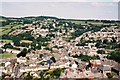
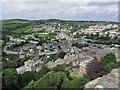
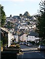
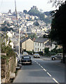
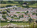
Launceston is a town, ancient borough, and civil parish in Cornwall, England, United Kingdom. It is 1 mile (1.6 km) west of the middle stage of the River Tamar, which constitutes almost the entire border between Cornwall and Devon. The landscape of the town is generally steep particularly at a sharp south-western knoll topped by Launceston Castle. These gradients fall down to the River Kensey and smaller tributaries.
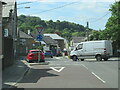
The town centre itself is bypassed and is no longer physically a main thoroughfare. The A388 still runs through the town close to the centre. The town remains figuratively the "gateway to Cornwall", due to having the A30, one of the two dual carriageways into the county, pass directly next to the town. The other dual carriageway and alternative main point of entry is the A38 at Saltash over the Tamar Bridge and was completed in 1962. There are smaller points of entry to Cornwall on minor roads.
Launceston Steam Railway narrow-gauge heritage railway runs as a tourist attraction during the summer months. It was restored for aesthetic and industrial heritage purposes and runs along a short rural route, it is popular with visitors but does not run for much of the year.
Launceston Castle was built by Robert, Count of Mortain (half-brother of William the Conqueror), c. 1070 to control the surrounding area. Launceston was the caput of the feudal barony of Launceston and of the Earldom of Cornwall until replaced by Lostwithiel in the 13th century. Launceston was later the county town of Cornwall until 1835 when Bodmin replaced it.
Two civil parishes serve the town and its outskirts, of which the central more built-up administrative unit housed 8,952 residents at the 2011 census.
Three electoral wards include reference to the town, their total population, from 2011 census data, being 11,837 and two ecclesiastical parishes serve the former single parish, with three churches and a large swathe of land to the north and west part of the area.
Launceston's motto "Royale et Loyale" (English translation: Royal and Loyal) is a reference to its adherence to the Cavalier cause during the English Civil War of the mid-17th century.
Summary for St. Marys Road, LAUNCESTON, PL15 8JN
Roadworks near PL15 8JN
Road Safety near PL15 8JN
Details of personal injury accidents in and around St. Marys Road, PL15 8JN that have been reported to Devon & Cornwall Police over the past 20 years.
Traffic Levels near PL15 8JN
View traffic levels near St. Marys Road, PL15 8JN from official Department for Transport counts.
Images taken near to St. Marys Road, PL15 8JN and the surrounding area
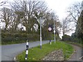
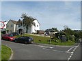
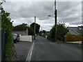
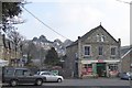
Please click the More button for more images, licensing and image copyright information.
Member of UK Parliament
This postcode is in the North Cornwall parliamentary constituency.
North Cornwall is a constituency in the South West region of England. The seat has been held by Scott Mann (Conservative) since May 2015.

Most Recent House Sales for St. Marys Road, PL15 8JN
25 Sep 2023
17 Sep 2021
18 Dec 2020
21 Jun 2019
Local Petrol Station Prices
Coordinates for PL15 8JN
Residents at PL15 8JN
Sunrise and Sunset at PL15 8JN
Traffic Emission and Congestion Zones
Historical Weather Summary
| Clear | 21.24% |
| Cloudy | 66.57% |
| Rain | 8.12% |
| Windy | 3.73% |
| Other | 0.34% |
Population
Deprivation Index
the more deprived the postcode
Average Energy Performance
Companies Registered at PL15 8JN
Postcode Details for PL15 8JN
Recent Updates
|
18 Apr 2024 Added Traffic Camera Views from Traffic Scotland to Roadworks within Scotland |
|
15 Apr 2024 Schools Data updated for April 2024 |
|
10 Apr 2024 Companies Data updated for March 2024 |
|
7 Apr 2024 New option to receive automatic updates to roadworks that affect you |
|
7 Apr 2024 Police and Crime data updated for February 2024 |
|
3 Apr 2024 Sold House Price data updated for February 2024 |
|
30 Mar 2024 Energy Performance Certificates (England and Wales) updated February 2024 |
|
28 Mar 2024 New feature to use Geolocating functions to detect your current location |
Random Postcodes
Want an idea of what is in our extensive website? Try somewhere completely random!
The Rural/Urban classification is based upon data collected during the 2011 Census and released in August 2013 and is categorised into 6 distinct classes.
[A] Urban Major conurbation: A built up area with a population of 10,000 (3,000 in Scotland) or more and is assigned to the major conurbation settlement category.
[B] Urban Minor conurbation: A built up area with a population of 10,000 (3,000 in Scotland) or more and is assigned to the minor conurbation settlement category.
[C] Urban City and town: A built up area with a population of 10,000 (3,000 in Scotland) or more and is assigned to the city and town settlement category.
[D] Rural Town and fringe
[E] Rural Village
[F] Rural Hamlet and isolated dwelling
The Index of Multiple Deprivation (IMD) is the official measure of relative deprivation.
The index is based on 39 separate indicators across seven distinct domains (Income; Employment; Health and Disability; Education, Skills and Training; Crime; Barriers to Housing and Services; Living Environment) to provide an overall measure of multiple deprivation and is calculated for every neighbourhood.
The index is relative rather than an absolute scale and so a neighbourhood with a score of 10 is more deprived than one rated 20, but this does not equate to being twice as deprived.
Please note: Different indices are used in England, Scotland, Wales and Northern Ireland and so comparison of scores from neighbourhoods in different countries should not be undertaken.
These figures report on incorporated UK companies only that are registered at this postcode and do not include sole-traders, partnerships or overseas organisations.
The population figure shown for your area are an estimate provided by the Office for National Statistics and is rounded to the nearest 1,000.
The estimates are derived from the Annual Population Survey (APS) which is the Labour Force Survey (LFS) plus various sample boosts.
There are 55 unitary authorities. They provide all local government services in their areas. These are mainly in the cities, urban areas and larger towns although there are now 6 shire county councils that are unitary (ie have no district councils beneath them).