Overview for High Street, FORT WILLIAM, PH33 6EG
Introduction
Fort William is a town in Lochaber in the Scottish Highlands, located on the eastern shore of Loch Linnhe. At the 2011 census, Fort William had a population of 10,459, making it the second largest settlement in both the Highland council area, and the whole of the Scottish Highlands; only the city of Inverness has a larger population.
Fort William is a major tourist centre on the Road to the Isles, with Glen Coe just to the south, Ben Nevis and Aonach Mòr to the east, and Glenfinnan to the west. It is a centre for hillwalking and climbing due to its proximity to Ben Nevis and many other Munros. It is also known for its nearby downhill mountain bike track. It is the start/end of both the West Highland Way (Milngavie – Fort William) and the Great Glen Way (a walk/cycle way Fort William–Inverness).
Around 726 people (7.33% of the population) can speak Gaelic.
Summary for High Street, FORT WILLIAM, PH33 6EG
Roadworks near PH33 6EG
Road Safety near PH33 6EG
Details of personal injury accidents in and around High Street, PH33 6EG that have been reported to over the past 20 years.
Traffic Levels near PH33 6EG
View traffic levels near High Street, PH33 6EG from official Department for Transport counts.
Images taken near to High Street, PH33 6EG and the surrounding area
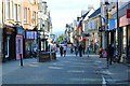
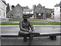

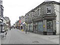
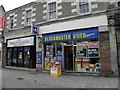
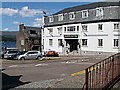
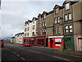
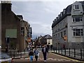
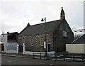
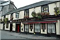
Please click the More button for more images, licensing and image copyright information.
Member of UK Parliament
This postcode is in the Ross, Skye and Lochaber parliamentary constituency.
Ross, Skye and Lochaber is a constituency in Scotland. The seat has been held by Ian Blackford (Scottish National Party) since May 2015.

Most Recent House Sales for High Street, PH33 6EG
No recorded house sales or transfers for this postcode.
Local Petrol Station Prices
Coordinates for PH33 6EG
Sunrise and Sunset at PH33 6EG
Traffic Emission and Congestion Zones
Historical Weather Summary
| Clear | 1.78% |
| Cloudy | 72.20% |
| Rain | 19.43% |
| Windy | 3.29% |
| Other | 3.30% |
Companies Registered at PH33 6EG
Postcode Details for PH33 6EG
Recent Updates
|
18 Apr 2024 Added Traffic Camera Views from Traffic Scotland to Roadworks within Scotland |
|
15 Apr 2024 Schools Data updated for April 2024 |
|
10 Apr 2024 Companies Data updated for March 2024 |
|
7 Apr 2024 New option to receive automatic updates to roadworks that affect you |
|
7 Apr 2024 Police and Crime data updated for February 2024 |
|
3 Apr 2024 Sold House Price data updated for February 2024 |
|
30 Mar 2024 Energy Performance Certificates (England and Wales) updated February 2024 |
|
28 Mar 2024 New feature to use Geolocating functions to detect your current location |
Random Postcodes
Want an idea of what is in our extensive website? Try somewhere completely random!
The Rural/Urban classification is based upon data collected during the 2011 Census and released in August 2013 and is categorised into 6 distinct classes.
[A] Urban Major conurbation: A built up area with a population of 10,000 (3,000 in Scotland) or more and is assigned to the major conurbation settlement category.
[B] Urban Minor conurbation: A built up area with a population of 10,000 (3,000 in Scotland) or more and is assigned to the minor conurbation settlement category.
[C] Urban City and town: A built up area with a population of 10,000 (3,000 in Scotland) or more and is assigned to the city and town settlement category.
[D] Rural Town and fringe
[E] Rural Village
[F] Rural Hamlet and isolated dwelling
The Index of Multiple Deprivation (IMD) is the official measure of relative deprivation.
The index is based on 39 separate indicators across seven distinct domains (Income; Employment; Health and Disability; Education, Skills and Training; Crime; Barriers to Housing and Services; Living Environment) to provide an overall measure of multiple deprivation and is calculated for every neighbourhood.
The index is relative rather than an absolute scale and so a neighbourhood with a score of 10 is more deprived than one rated 20, but this does not equate to being twice as deprived.
Please note: Different indices are used in England, Scotland, Wales and Northern Ireland and so comparison of scores from neighbourhoods in different countries should not be undertaken.
These figures report on incorporated UK companies only that are registered at this postcode and do not include sole-traders, partnerships or overseas organisations.
The population figure shown for your area are an estimate provided by the Office for National Statistics and is rounded to the nearest 1,000.
The estimates are derived from the Annual Population Survey (APS) which is the Labour Force Survey (LFS) plus various sample boosts.
Large User Postcode
This postcode is designated a large user postcode. A large user postcode is assigned by Royal Mail to those organisations typically receiving at least 500 mail items per day and so will usually be found assigned to business premises.
There are 55 unitary authorities. They provide all local government services in their areas. These are mainly in the cities, urban areas and larger towns although there are now 6 shire county councils that are unitary (ie have no district councils beneath them).