Overview for Port Appin, APPIN, PA38 4DQ
Introduction
Appin is a coastal district of the Scottish West Highlands bounded to the west by Loch Linnhe, to the south by Loch Creran, to the east by the districts of Benderloch and Lorne, and to the north by Loch Leven. It lies northeast to southwest, and measures 23 by 11 kilometres (14 by 7 miles). The name, meaning "abbey land", in reference to Ligmore Abbey, is derived from the Middle Irish apdaine.
The district is mainly in Argyll and Bute, with a coastal strip to the north, along Loch Leven, within the Highland council area.
The scenery of the district is a combination of seascapes with rugged and mountainous country inland. Appin forms part of the Lynn of Lorn National Scenic Area, one of 40 in Scotland. The principal hills are double peaks of Beinn a' Bheithir – 1,025 and 1,001 m (3,362 and 3,284 ft), respectively – and Creag Ghorm – 723 m (2,372 ft) – in the north, and Fraochaidh 879 m (2,883 ft), Meall Bàn 655 m (2,148 ft) and Beinn Mhic na Cèisich 638 m (2,093 ft) near the western flank of Glen Creran. The chief rivers are the Coe and Laroch, flowing into Loch Leven, the Duror and Salachan flowing into Loch Linnhe, and the Iola and Creran flowing into Loch Creran.
The leading industries are forestry and tourism, with lead mining and slate quarrying being of former importance, but the Glensanda superquarry, in Morvern on the opposite bank of Loch Linnhe also provides local employment. Ballachulish, Duror, Portnacroish, Appin Village and Port Appin are the principal villages.
Appin was the country of a distinct local branch of Clan Stewart.
The A828 road runs along the coast of Appin. A passenger-only ferry to the island of Lismore runs from Port Appin. The district formerly had a railway, but the Caledonian Railway company's branch line from Connel to Ballachulish was closed in 1966.
Appin is where the Appin Murder took place in 1752.
Summary for Port Appin, APPIN, PA38 4DQ
Roadworks near PA38 4DQ
Road Safety near PA38 4DQ
Details of personal injury accidents in and around PA38 4DQ that have been reported to over the past 20 years.
Traffic Levels near PA38 4DQ
View traffic levels near PA38 4DQ from official Department for Transport counts.
Images taken in and around the pa384dq area
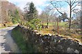
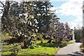
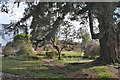
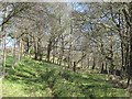
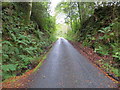
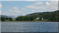
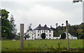
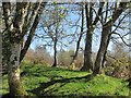
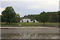
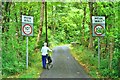
Please click the More button for more images, licensing and image copyright information.
Member of UK Parliament
This postcode is in the Argyll and Bute parliamentary constituency.
Argyll and Bute is a constituency in Scotland. The seat has been held by Brendan O'Hara (Scottish National Party) since May 2015.

Most Recent House Sales for PA38 4DQ
No recorded house sales or transfers for this postcode.
Local Petrol Station Prices
Coordinates for PA38 4DQ
Sunrise and Sunset at PA38 4DQ
Traffic Emission and Congestion Zones
Historical Weather Summary
| Clear | 4.13% |
| Cloudy | 61.84% |
| Rain | 18.19% |
| Windy | 15.65% |
| Other | 0.19% |
Average Energy Performance
Companies Registered at PA38 4DQ
Postcode Details for PA38 4DQ
Recent Updates
|
18 Apr 2024 Added Traffic Camera Views from Traffic Scotland to Roadworks within Scotland |
|
15 Apr 2024 Schools Data updated for April 2024 |
|
10 Apr 2024 Companies Data updated for March 2024 |
|
7 Apr 2024 New option to receive automatic updates to roadworks that affect you |
|
7 Apr 2024 Police and Crime data updated for February 2024 |
|
3 Apr 2024 Sold House Price data updated for February 2024 |
|
30 Mar 2024 Energy Performance Certificates (England and Wales) updated February 2024 |
|
28 Mar 2024 New feature to use Geolocating functions to detect your current location |
Random Postcodes
Want an idea of what is in our extensive website? Try somewhere completely random!
The Rural/Urban classification is based upon data collected during the 2011 Census and released in August 2013 and is categorised into 6 distinct classes.
[A] Urban Major conurbation: A built up area with a population of 10,000 (3,000 in Scotland) or more and is assigned to the major conurbation settlement category.
[B] Urban Minor conurbation: A built up area with a population of 10,000 (3,000 in Scotland) or more and is assigned to the minor conurbation settlement category.
[C] Urban City and town: A built up area with a population of 10,000 (3,000 in Scotland) or more and is assigned to the city and town settlement category.
[D] Rural Town and fringe
[E] Rural Village
[F] Rural Hamlet and isolated dwelling
The Index of Multiple Deprivation (IMD) is the official measure of relative deprivation.
The index is based on 39 separate indicators across seven distinct domains (Income; Employment; Health and Disability; Education, Skills and Training; Crime; Barriers to Housing and Services; Living Environment) to provide an overall measure of multiple deprivation and is calculated for every neighbourhood.
The index is relative rather than an absolute scale and so a neighbourhood with a score of 10 is more deprived than one rated 20, but this does not equate to being twice as deprived.
Please note: Different indices are used in England, Scotland, Wales and Northern Ireland and so comparison of scores from neighbourhoods in different countries should not be undertaken.
These figures report on incorporated UK companies only that are registered at this postcode and do not include sole-traders, partnerships or overseas organisations.
The population figure shown for your area are an estimate provided by the Office for National Statistics and is rounded to the nearest 1,000.
The estimates are derived from the Annual Population Survey (APS) which is the Labour Force Survey (LFS) plus various sample boosts.
There are 55 unitary authorities. They provide all local government services in their areas. These are mainly in the cities, urban areas and larger towns although there are now 6 shire county councils that are unitary (ie have no district councils beneath them).