Overview for St. Helens Road, CAERNARFON, LL55 2PF
Introduction
Caernarfon is a royal town, community and port in Gwynedd, Wales. It has a population of 9,852 (with Caeathro). It lies along the A487 road, on the eastern shore of the Menai Strait, opposite the island of Anglesey. The city of Bangor is 8.6 miles (13.8 km) to the north-east, while Snowdonia (Eryri) fringes Caernarfon to the east and south-east.
Abundant natural resources in and around the Menai Strait enabled human habitation in prehistoric Britain. The Ordovices, a Celtic tribe, lived in the region during the period known as Roman Britain. The Roman fort Segontium was established around AD 80 to subjugate the Ordovices during the Roman conquest of Britain. The Romans occupied the region until the end of Roman rule in Britain in 382, after which Caernarfon became part of the Kingdom of Gwynedd. In the late 11th century, William the Conqueror ordered the construction of a motte-and-bailey castle at Caernarfon as part of the Norman invasion of Wales. He was unsuccessful, and Wales remained independent until around 1283.
In the 13th century, Llywelyn ap Gruffudd, ruler of Gwynedd, refused to pay homage to Edward I of England, prompting the English conquest of Gwynedd. This was followed by the construction of Caernarfon Castle, one of the largest and most imposing fortifications built by the English in Wales. In 1284, the English-style county of Caernarfonshire was established by the Statute of Rhuddlan; the same year, Caernarfon was made a borough, a county and market town, and the seat of English government in north Wales.
The ascent of the House of Tudor to the throne of England eased hostilities with the English and resulted in Caernarfon Castle falling into a state of disrepair. The town has flourished, leading to its status as a major tourist centre and seat of Gwynedd Council, with a thriving harbour and marina. Caernarfon has expanded beyond its medieval walls and experienced heavy suburbanisation. The community of Caernarfon's population includes the highest percentage of Welsh-speaking citizens anywhere in Wales. The status of Royal Borough was granted by Queen Elizabeth II in 1963 and amended to Royal Town in 1974. The castle and town walls are part of a World Heritage Site described as the Castles and Town Walls of King Edward in Gwynedd.
Summary for St. Helens Road, CAERNARFON, LL55 2PF
Roadworks near LL55 2PF
A local roadworks feed is not available for Wales at this time.
However, Traffic Wales/Traffig Cymru provide works details for motorways and major trunk roads in Wales on their website at traffic.wales/roadworks
Road Safety near LL55 2PF
Details of personal injury accidents in and around St. Helens Road, LL55 2PF that have been reported to North Wales Police over the past 20 years.
Traffic Levels near LL55 2PF
View traffic levels near St. Helens Road, LL55 2PF from official Department for Transport counts.
Images taken near to St. Helens Road, LL55 2PF and the surrounding area
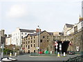
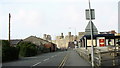

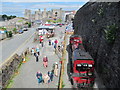
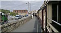

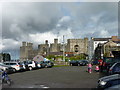
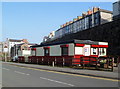
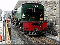
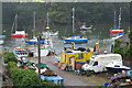
Please click the More button for more images, licensing and image copyright information.
Member of UK Parliament
This postcode is in the Arfon parliamentary constituency.
Arfon is a constituency in Wales. The seat has been held by Hywel Williams (Plaid Cymru) since May 2010.

Most Recent House Sales for St. Helens Road, LL55 2PF
No recorded house sales or transfers for this postcode.
Local Petrol Station Prices
Coordinates for LL55 2PF
Residents at LL55 2PF
Sunrise and Sunset at LL55 2PF
Traffic Emission and Congestion Zones
Historical Weather Summary
| Clear | 14.54% |
| Cloudy | 66.34% |
| Rain | 11.00% |
| Windy | 7.40% |
| Other | 0.72% |
Population
Deprivation Index
the more deprived the postcode
Companies Registered at LL55 2PF
Postcode Details for LL55 2PF
Recent Updates
|
15 Apr 2024 Schools Data updated for April 2024 |
|
10 Apr 2024 Companies Data updated for March 2024 |
|
7 Apr 2024 New option to receive automatic updates to roadworks that affect you |
|
7 Apr 2024 Police and Crime data updated for February 2024 |
|
3 Apr 2024 Sold House Price data updated for February 2024 |
|
30 Mar 2024 Energy Performance Certificates (England and Wales) updated February 2024 |
|
28 Mar 2024 New feature to use Geolocating functions to detect your current location |
|
17 Mar 2024 Schools Data updated for March 2024 |
Random Postcodes
Want an idea of what is in our extensive website? Try somewhere completely random!
The Rural/Urban classification is based upon data collected during the 2011 Census and released in August 2013 and is categorised into 6 distinct classes.
[A] Urban Major conurbation: A built up area with a population of 10,000 (3,000 in Scotland) or more and is assigned to the major conurbation settlement category.
[B] Urban Minor conurbation: A built up area with a population of 10,000 (3,000 in Scotland) or more and is assigned to the minor conurbation settlement category.
[C] Urban City and town: A built up area with a population of 10,000 (3,000 in Scotland) or more and is assigned to the city and town settlement category.
[D] Rural Town and fringe
[E] Rural Village
[F] Rural Hamlet and isolated dwelling
The Index of Multiple Deprivation (IMD) is the official measure of relative deprivation.
The index is based on 39 separate indicators across seven distinct domains (Income; Employment; Health and Disability; Education, Skills and Training; Crime; Barriers to Housing and Services; Living Environment) to provide an overall measure of multiple deprivation and is calculated for every neighbourhood.
The index is relative rather than an absolute scale and so a neighbourhood with a score of 10 is more deprived than one rated 20, but this does not equate to being twice as deprived.
Please note: Different indices are used in England, Scotland, Wales and Northern Ireland and so comparison of scores from neighbourhoods in different countries should not be undertaken.
These figures report on incorporated UK companies only that are registered at this postcode and do not include sole-traders, partnerships or overseas organisations.
The population figure shown for your area are an estimate provided by the Office for National Statistics and is rounded to the nearest 1,000.
The estimates are derived from the Annual Population Survey (APS) which is the Labour Force Survey (LFS) plus various sample boosts.
There are 55 unitary authorities. They provide all local government services in their areas. These are mainly in the cities, urban areas and larger towns although there are now 6 shire county councils that are unitary (ie have no district councils beneath them).