Overview for Leeming Lane, CARNFORTH, LA6 3LD
Introduction
Carnforth is a market town and civil parish in the City of Lancaster in Lancashire, England, situated at the north-east end of Morecambe Bay. The parish of Carnforth had a population of 5,560 in the 2011 census, an increase from the 5,350 recorded in the 2001 census. The town is situated around 7 miles north of Lancaster, 17 miles south of Kendal, 40 miles east (bisected by Morecambe Bay) of Barrow-in-Furness and 28 miles northwest of Settle. The town is also close to the Cumbria/Lancashire border.
Carnforth grew in the 19th century through the presence of the railway and ironworks. Due to the closeness of the coast and the hills, Carnforth is a popular base for walkers and cyclists exploring the area. The River Keer, the West Coast Main Line (WCML), the A6 and the Lancaster Canal pass through the town. The M6 motorway passes just to the east, linked to Carnforth by the A6070 (formerly the A601(M)) which was originally part of the Lancaster bypass before the M6 was extended north.
Summary for Leeming Lane, CARNFORTH, LA6 3LD
Roadworks near LA6 3LD
Road Safety near LA6 3LD
Details of personal injury accidents in and around Leeming Lane, LA6 3LD that have been reported to North Yorkshire Police over the past 20 years.
Traffic Levels near LA6 3LD
View traffic levels near Leeming Lane, LA6 3LD from official Department for Transport counts.
Images taken near to Leeming Lane, LA6 3LD and the surrounding area
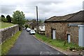

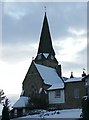


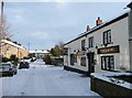

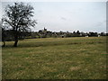

Please click the More button for more images, licensing and image copyright information.
Member of UK Parliament
This postcode is in the Skipton and Ripon parliamentary constituency.
Skipton and Ripon is a constituency in the Yorkshire and The Humber region of England. The seat has been held by Julian Smith (Conservative) since May 2010.

Most Recent House Sales for Leeming Lane, LA6 3LD
10 Jul 2017
12 Jul 2013
13 Sep 2010
21 May 2010
Local Petrol Station Prices
Coordinates for LA6 3LD
Residents at LA6 3LD
Sunrise and Sunset at LA6 3LD
Traffic Emission and Congestion Zones
Historical Weather Summary
| Clear | 5.32% |
| Cloudy | 60.44% |
| Rain | 16.46% |
| Windy | 15.69% |
| Other | 2.09% |
Deprivation Index
the more deprived the postcode
Average Energy Performance
Companies Registered at LA6 3LD
Postcode Details for LA6 3LD
Recent Updates
|
18 Apr 2024 Added Traffic Camera Views from Traffic Scotland to Roadworks within Scotland |
|
15 Apr 2024 Schools Data updated for April 2024 |
|
10 Apr 2024 Companies Data updated for March 2024 |
|
7 Apr 2024 New option to receive automatic updates to roadworks that affect you |
|
7 Apr 2024 Police and Crime data updated for February 2024 |
|
3 Apr 2024 Sold House Price data updated for February 2024 |
|
30 Mar 2024 Energy Performance Certificates (England and Wales) updated February 2024 |
|
28 Mar 2024 New feature to use Geolocating functions to detect your current location |
Random Postcodes
Want an idea of what is in our extensive website? Try somewhere completely random!
The Rural/Urban classification is based upon data collected during the 2011 Census and released in August 2013 and is categorised into 6 distinct classes.
[A] Urban Major conurbation: A built up area with a population of 10,000 (3,000 in Scotland) or more and is assigned to the major conurbation settlement category.
[B] Urban Minor conurbation: A built up area with a population of 10,000 (3,000 in Scotland) or more and is assigned to the minor conurbation settlement category.
[C] Urban City and town: A built up area with a population of 10,000 (3,000 in Scotland) or more and is assigned to the city and town settlement category.
[D] Rural Town and fringe
[E] Rural Village
[F] Rural Hamlet and isolated dwelling
The Index of Multiple Deprivation (IMD) is the official measure of relative deprivation.
The index is based on 39 separate indicators across seven distinct domains (Income; Employment; Health and Disability; Education, Skills and Training; Crime; Barriers to Housing and Services; Living Environment) to provide an overall measure of multiple deprivation and is calculated for every neighbourhood.
The index is relative rather than an absolute scale and so a neighbourhood with a score of 10 is more deprived than one rated 20, but this does not equate to being twice as deprived.
Please note: Different indices are used in England, Scotland, Wales and Northern Ireland and so comparison of scores from neighbourhoods in different countries should not be undertaken.
These figures report on incorporated UK companies only that are registered at this postcode and do not include sole-traders, partnerships or overseas organisations.
The population figure shown for your area are an estimate provided by the Office for National Statistics and is rounded to the nearest 1,000.
The estimates are derived from the Annual Population Survey (APS) which is the Labour Force Survey (LFS) plus various sample boosts.
There are 55 unitary authorities. They provide all local government services in their areas. These are mainly in the cities, urban areas and larger towns although there are now 6 shire county councils that are unitary (ie have no district councils beneath them).