Overview for Peterlee Way, BOOTLE, L30 1SH
Introduction
Bootle is a town in the Metropolitan Borough of Sefton, Merseyside, England, which had a population of 51,394 in 2011; the wider Parliamentary constituency had a population of 98,449.
Historically part of Lancashire, Bootle's proximity to the Irish Sea and the industrial city of Liverpool to the south saw it grow rapidly in the 1800s, first as a dormitory town for wealthy merchants, and then as a centre of commerce and industry in its own right following the arrival of the railway and the expansion of the docks and shipping industries. The subsequent population increase was fuelled heavily by Irish migration.
The town was heavily damaged in World War II with air raids against the port and other industrial targets. Post-war economic success in the 1950s and 1960s gave way to a downturn, precipitated by a reduction in the significance of Liverpool Docks internationally, and changing levels of industrialisation, coupled with the development of modern suburbs and the expansion of industries into the Merseyside hinterlands. By the 1980s, there had been a sharp spike in unemployment and population decline. Large-scale renewal projects have begun to help regenerate the local economy.
Summary for Peterlee Way, BOOTLE, L30 1SH
Roadworks near L30 1SH
Road Safety near L30 1SH
Details of personal injury accidents in and around Peterlee Way, L30 1SH that have been reported to Merseyside Police over the past 20 years.
Traffic Levels near L30 1SH
View traffic levels near Peterlee Way, L30 1SH from official Department for Transport counts.
Images taken near to Peterlee Way, L30 1SH and the surrounding area
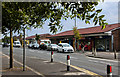
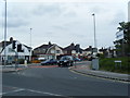


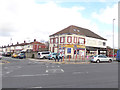

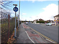

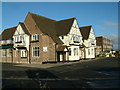
Please click the More button for more images, licensing and image copyright information.
Police
This area is policed by Merseyside Police.
Merseyside Police split their policing area into 139 separate neighbourhoods and this postcode is in the Netherton and Orrell neighbourhood.

Netherton and Orrell Neighbourhood Crime
Top 3 Categories
For full details of all categories together with more crime information, click on the Details button.
Member of UK Parliament
This postcode is in the Bootle parliamentary constituency.
Bootle is a constituency in the North West region of England. The seat has been held by Peter Dowd (Labour) since May 2015.

Most Recent House Sales for Peterlee Way, L30 1SH
17 Mar 2023
4 Jul 2022
25 Feb 2022
29 Nov 2021
Local Petrol Station Prices
Coordinates for L30 1SH
Residents at L30 1SH
Sunrise and Sunset at L30 1SH
Traffic Emission and Congestion Zones
Historical Weather Summary
| Clear | 17.86% |
| Cloudy | 60.05% |
| Rain | 7.61% |
| Windy | 14.42% |
| Other | 0.06% |
Population
Deprivation Index
the more deprived the postcode
Average Energy Performance
Companies Registered at L30 1SH
Postcode Details for L30 1SH
Recent Updates
|
18 Apr 2024 Added Traffic Camera Views from Traffic Scotland to Roadworks within Scotland |
|
15 Apr 2024 Schools Data updated for April 2024 |
|
10 Apr 2024 Companies Data updated for March 2024 |
|
7 Apr 2024 New option to receive automatic updates to roadworks that affect you |
|
7 Apr 2024 Police and Crime data updated for February 2024 |
|
3 Apr 2024 Sold House Price data updated for February 2024 |
|
30 Mar 2024 Energy Performance Certificates (England and Wales) updated February 2024 |
|
28 Mar 2024 New feature to use Geolocating functions to detect your current location |
Random Postcodes
Want an idea of what is in our extensive website? Try somewhere completely random!
The Rural/Urban classification is based upon data collected during the 2011 Census and released in August 2013 and is categorised into 6 distinct classes.
[A] Urban Major conurbation: A built up area with a population of 10,000 (3,000 in Scotland) or more and is assigned to the major conurbation settlement category.
[B] Urban Minor conurbation: A built up area with a population of 10,000 (3,000 in Scotland) or more and is assigned to the minor conurbation settlement category.
[C] Urban City and town: A built up area with a population of 10,000 (3,000 in Scotland) or more and is assigned to the city and town settlement category.
[D] Rural Town and fringe
[E] Rural Village
[F] Rural Hamlet and isolated dwelling
The Index of Multiple Deprivation (IMD) is the official measure of relative deprivation.
The index is based on 39 separate indicators across seven distinct domains (Income; Employment; Health and Disability; Education, Skills and Training; Crime; Barriers to Housing and Services; Living Environment) to provide an overall measure of multiple deprivation and is calculated for every neighbourhood.
The index is relative rather than an absolute scale and so a neighbourhood with a score of 10 is more deprived than one rated 20, but this does not equate to being twice as deprived.
Please note: Different indices are used in England, Scotland, Wales and Northern Ireland and so comparison of scores from neighbourhoods in different countries should not be undertaken.
These figures report on incorporated UK companies only that are registered at this postcode and do not include sole-traders, partnerships or overseas organisations.
The population figure shown for your area are an estimate provided by the Office for National Statistics and is rounded to the nearest 1,000.
The estimates are derived from the Annual Population Survey (APS) which is the Labour Force Survey (LFS) plus various sample boosts.
There are 36 metropolitan district councils which together cover 6 large urban areas: the counties of Greater Manchester, Merseyside, South Yorkshire, Tyne and Wear, West Midlands, and West Yorkshire.
Metropolitan districts are responsible for all services in their area, although certain conurbation wide services such as fire and civil defence, police, waste disposal and passenger transport are provided through joint authorities (the districts acting jointly).