Overview for Midcroft, RUISLIP, HA4 8EP
Introduction
Ruislip (RY-slip) is an area in the London Borough of Hillingdon in West London. Prior to 1965 it was in Middlesex. Ruislip lies 13.8 miles (22.2 km) west-north-west of Charing Cross, London.
The manor of Ruislip appears in the Domesday Book, and some of the earliest settlements still exist today, designated as local heritage sites. The parish church, St Martin's, dates back to the 13th century and remains in use. The buildings at the northern end of Ruislip High Street form the core of the original village square and are now Grade II listed. It originally featured a central water pump, but this was moved out of the road in the 1970s as a result of increased traffic.
The expansion of the Metropolitan Railway from Harrow in the early 20th century acted as a catalyst for development in the area. Ruislip station opened in 1904, and a new urban district was created to reflect the forthcoming population growth; the Ruislip-Northwood Urban District split from the Uxbridge Rural District and continued until 1965, when Ruislip became part of the newly established London Borough of Hillingdon.
Major landmarks in the area include Ruislip Lido, a former reservoir, now an area of public parkland with its own miniature railway and Manor Farm, a settlement dating from the 9th century which is now designated as a local heritage site.
Ruislip is included within the Ruislip, Northwood and Pinner and Uxbridge & South Ruislip parliamentary constituencies and is covered by three electoral wards within the local council. As of the 2019 general election, Ruislip is represented by two Conservative MPs: the former Prime Minister Boris Johnson, and David Simmonds.
Summary for Midcroft, RUISLIP, HA4 8EP
Roadworks near HA4 8EP
Road Safety near HA4 8EP
Details of personal injury accidents in and around Midcroft, HA4 8EP that have been reported to Metropolitan Police Service over the past 20 years.
Traffic Levels near HA4 8EP
View traffic levels near Midcroft, HA4 8EP from official Department for Transport counts.
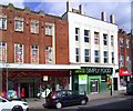
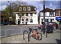
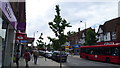
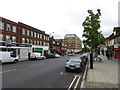
Images taken near to Midcroft, HA4 8EP and the surrounding area
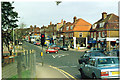
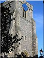
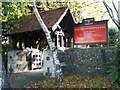
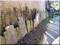
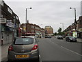
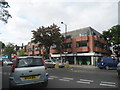
Please click the More button for more images, licensing and image copyright information.
Member of UK Parliament
This postcode is in the Ruislip, Northwood and Pinner parliamentary constituency.
Ruislip, Northwood and Pinner is a constituency in London, England. The seat has been held by David Simmonds (Conservative) since December 2019.

Most Recent House Sales for Midcroft, HA4 8EP
27 Jun 2011
20 Jun 2007
31 Mar 2003
21 Mar 2003
Local Petrol Station Prices
Coordinates for HA4 8EP
Residents at HA4 8EP
Sunrise and Sunset at HA4 8EP
Traffic Emission Zones
Historical Weather Summary
| Clear | 8.97% |
| Cloudy | 79.12% |
| Rain | 8.21% |
| Windy | 3.66% |
| Other | 0.04% |
Population
Deprivation Index
the more deprived the postcode
Average Energy Performance
Companies Registered at HA4 8EP
Postcode Details for HA4 8EP
Recent Updates
|
18 Apr 2024 Added Traffic Camera Views from Traffic Scotland to Roadworks within Scotland |
|
15 Apr 2024 Schools Data updated for April 2024 |
|
10 Apr 2024 Companies Data updated for March 2024 |
|
7 Apr 2024 New option to receive automatic updates to roadworks that affect you |
|
7 Apr 2024 Police and Crime data updated for February 2024 |
|
3 Apr 2024 Sold House Price data updated for February 2024 |
|
30 Mar 2024 Energy Performance Certificates (England and Wales) updated February 2024 |
|
28 Mar 2024 New feature to use Geolocating functions to detect your current location |
Random Postcodes
Want an idea of what is in our extensive website? Try somewhere completely random!
The Rural/Urban classification is based upon data collected during the 2011 Census and released in August 2013 and is categorised into 6 distinct classes.
[A] Urban Major conurbation: A built up area with a population of 10,000 (3,000 in Scotland) or more and is assigned to the major conurbation settlement category.
[B] Urban Minor conurbation: A built up area with a population of 10,000 (3,000 in Scotland) or more and is assigned to the minor conurbation settlement category.
[C] Urban City and town: A built up area with a population of 10,000 (3,000 in Scotland) or more and is assigned to the city and town settlement category.
[D] Rural Town and fringe
[E] Rural Village
[F] Rural Hamlet and isolated dwelling
The Index of Multiple Deprivation (IMD) is the official measure of relative deprivation.
The index is based on 39 separate indicators across seven distinct domains (Income; Employment; Health and Disability; Education, Skills and Training; Crime; Barriers to Housing and Services; Living Environment) to provide an overall measure of multiple deprivation and is calculated for every neighbourhood.
The index is relative rather than an absolute scale and so a neighbourhood with a score of 10 is more deprived than one rated 20, but this does not equate to being twice as deprived.
Please note: Different indices are used in England, Scotland, Wales and Northern Ireland and so comparison of scores from neighbourhoods in different countries should not be undertaken.
These figures report on incorporated UK companies only that are registered at this postcode and do not include sole-traders, partnerships or overseas organisations.
The population figure shown for your area are an estimate provided by the Office for National Statistics and is rounded to the nearest 1,000.
The estimates are derived from the Annual Population Survey (APS) which is the Labour Force Survey (LFS) plus various sample boosts.
There are 32 London boroughs. They provide nearly all the services in their area. However, the Greater London Authority (GLA) provides London-wide government, including special responsibility for police, fire, strategic planning and transport.