Overview for Kirk Court, TILLICOULTRY, FK13 6QN
Introduction
Tillicoultry is a town in Clackmannanshire, Scotland. Tillicoultry is usually referred to as Tilly by the locals.
One of the Hillfoots Villages on the A91, which runs from Stirling to St. Andrews, Tillicoultry is situated at the southern base of the Ochil Hills, which provide a spectacular backdrop. The River Devon lies to the south. The river also runs through neighbouring villages Dollar and Alva to the east and west respectively. The former mining village of Coalsnaughton lies just south, whilst Alloa lies 4 miles (6 kilometres) southwest.
The "hill" referred to in the first etymology is likely to be Kirkhill, at the east of the town. The alternative Latin etymology, Tellus culta, the cultivated land, suggested by Rev. William Osborne, minister of the parish from 1773 to 1794, is also possible. However, as both etymologies could equally be applied to a hundred places in Scotland, both are suspect, as neither define the town in a unique manner.
Summary for Kirk Court, TILLICOULTRY, FK13 6QN
Roadworks near FK13 6QN
Road Safety near FK13 6QN
Details of personal injury accidents in and around Kirk Court, FK13 6QN that have been reported to over the past 20 years.
Traffic Levels near FK13 6QN
View traffic levels near Kirk Court, FK13 6QN from official Department for Transport counts.
Images taken near to Kirk Court, FK13 6QN and the surrounding area
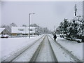
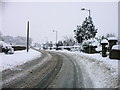
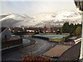
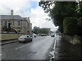
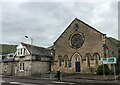
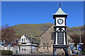
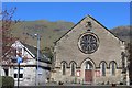
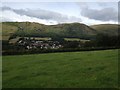
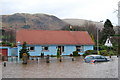
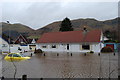
Please click the More button for more images, licensing and image copyright information.
Member of UK Parliament
This postcode is in the Ochil and South Perthshire parliamentary constituency.
Ochil and South Perthshire is a constituency in Scotland. The seat has been held by John Nicolson (Scottish National Party) since December 2019.

Most Recent House Sales for Kirk Court, FK13 6QN
No recorded house sales or transfers for this postcode.
Local Petrol Station Prices
Coordinates for FK13 6QN
Sunrise and Sunset at FK13 6QN
Traffic Emission and Congestion Zones
Historical Weather Summary
| Clear | 7.27% |
| Cloudy | 58.99% |
| Rain | 11.31% |
| Windy | 20.89% |
| Other | 1.54% |
Average Energy Performance
Companies Registered at FK13 6QN
Postcode Details for FK13 6QN
Recent Updates
|
18 Apr 2024 Added Traffic Camera Views from Traffic Scotland to Roadworks within Scotland |
|
15 Apr 2024 Schools Data updated for April 2024 |
|
10 Apr 2024 Companies Data updated for March 2024 |
|
7 Apr 2024 New option to receive automatic updates to roadworks that affect you |
|
7 Apr 2024 Police and Crime data updated for February 2024 |
|
3 Apr 2024 Sold House Price data updated for February 2024 |
|
30 Mar 2024 Energy Performance Certificates (England and Wales) updated February 2024 |
|
28 Mar 2024 New feature to use Geolocating functions to detect your current location |
Random Postcodes
Want an idea of what is in our extensive website? Try somewhere completely random!
The Rural/Urban classification is based upon data collected during the 2011 Census and released in August 2013 and is categorised into 6 distinct classes.
[A] Urban Major conurbation: A built up area with a population of 10,000 (3,000 in Scotland) or more and is assigned to the major conurbation settlement category.
[B] Urban Minor conurbation: A built up area with a population of 10,000 (3,000 in Scotland) or more and is assigned to the minor conurbation settlement category.
[C] Urban City and town: A built up area with a population of 10,000 (3,000 in Scotland) or more and is assigned to the city and town settlement category.
[D] Rural Town and fringe
[E] Rural Village
[F] Rural Hamlet and isolated dwelling
The Index of Multiple Deprivation (IMD) is the official measure of relative deprivation.
The index is based on 39 separate indicators across seven distinct domains (Income; Employment; Health and Disability; Education, Skills and Training; Crime; Barriers to Housing and Services; Living Environment) to provide an overall measure of multiple deprivation and is calculated for every neighbourhood.
The index is relative rather than an absolute scale and so a neighbourhood with a score of 10 is more deprived than one rated 20, but this does not equate to being twice as deprived.
Please note: Different indices are used in England, Scotland, Wales and Northern Ireland and so comparison of scores from neighbourhoods in different countries should not be undertaken.
These figures report on incorporated UK companies only that are registered at this postcode and do not include sole-traders, partnerships or overseas organisations.
The population figure shown for your area are an estimate provided by the Office for National Statistics and is rounded to the nearest 1,000.
The estimates are derived from the Annual Population Survey (APS) which is the Labour Force Survey (LFS) plus various sample boosts.
There are 55 unitary authorities. They provide all local government services in their areas. These are mainly in the cities, urban areas and larger towns although there are now 6 shire county councils that are unitary (ie have no district councils beneath them).