Overview for Norway Lane, BEAMINSTER, DT8 3JS
Introduction
Beaminster (BEM-in-stər) is a town and civil parish in Dorset, England, situated in the Dorset Council administrative area approximately 15 miles (24 km) northwest of the county town Dorchester. It is sited in a bowl-shaped valley near the source of the small River Brit. The 2013 mid-year estimate of the population of Beaminster parish is 3,100.
Beaminster is the product of the Anglo-Saxon age, dating back to around the 7th century, when it was known as Bebingmynster, meaning the church of Bebbe although the date of origin of the town is unknown. The place name and historic evidence indicates that it was probably the site of a primary Saxon minster church and was at the centre of a large episcopal estate. These are likely to have acted as a focus for a settlement, but evidence of its formation is lacking.
In its history Beaminster has been a centre of manufacture of linen and woollens, the raw materials for which were produced in the surrounding countryside. The town experienced three serious fires in the 17th and 18th centuries; the first of these, during the English Civil War, almost destroyed the fabric of the town.
Beaminster parish church is notable for its architecture, particularly its tower.
Summary for Norway Lane, BEAMINSTER, DT8 3JS
Roadworks near DT8 3JS
Road Safety near DT8 3JS
Details of personal injury accidents in and around Norway Lane, DT8 3JS that have been reported to Dorset Police over the past 20 years.
Traffic Levels near DT8 3JS
View traffic levels near Norway Lane, DT8 3JS from official Department for Transport counts.
Images taken near to Norway Lane, DT8 3JS and the surrounding area
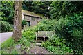
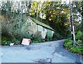

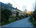
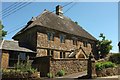


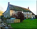
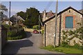

Please click the More button for more images, licensing and image copyright information.
Police
This area is policed by Dorset Police.
Dorset Police split their policing area into 21 separate neighbourhoods and this postcode is in the Bridport neighbourhood.

Bridport Neighbourhood Crime
Top 3 Categories
For full details of all categories together with more crime information, click on the Details button.
Member of UK Parliament
This postcode is in the West Dorset parliamentary constituency.
West Dorset is a constituency in the South West region of England. The seat has been held by Chris Loder (Conservative) since December 2019.

Most Recent House Sales for Norway Lane, DT8 3JS
27 Sep 2013
23 Jun 2010
28 Apr 2006
9 Aug 2004
Local Petrol Station Prices
Coordinates for DT8 3JS
Residents at DT8 3JS
Sunrise and Sunset at DT8 3JS
Traffic Emission and Congestion Zones
Historical Weather Summary
| Clear | 23.13% |
| Cloudy | 64.22% |
| Rain | 7.80% |
| Windy | 4.62% |
| Other | 0.23% |
Deprivation Index
the more deprived the postcode
Average Energy Performance
Companies Registered at DT8 3JS
Postcode Details for DT8 3JS
Recent Updates
|
18 Apr 2024 Added Traffic Camera Views from Traffic Scotland to Roadworks within Scotland |
|
15 Apr 2024 Schools Data updated for April 2024 |
|
10 Apr 2024 Companies Data updated for March 2024 |
|
7 Apr 2024 New option to receive automatic updates to roadworks that affect you |
|
7 Apr 2024 Police and Crime data updated for February 2024 |
|
3 Apr 2024 Sold House Price data updated for February 2024 |
|
30 Mar 2024 Energy Performance Certificates (England and Wales) updated February 2024 |
|
28 Mar 2024 New feature to use Geolocating functions to detect your current location |
Random Postcodes
Want an idea of what is in our extensive website? Try somewhere completely random!
The Rural/Urban classification is based upon data collected during the 2011 Census and released in August 2013 and is categorised into 6 distinct classes.
[A] Urban Major conurbation: A built up area with a population of 10,000 (3,000 in Scotland) or more and is assigned to the major conurbation settlement category.
[B] Urban Minor conurbation: A built up area with a population of 10,000 (3,000 in Scotland) or more and is assigned to the minor conurbation settlement category.
[C] Urban City and town: A built up area with a population of 10,000 (3,000 in Scotland) or more and is assigned to the city and town settlement category.
[D] Rural Town and fringe
[E] Rural Village
[F] Rural Hamlet and isolated dwelling
The Index of Multiple Deprivation (IMD) is the official measure of relative deprivation.
The index is based on 39 separate indicators across seven distinct domains (Income; Employment; Health and Disability; Education, Skills and Training; Crime; Barriers to Housing and Services; Living Environment) to provide an overall measure of multiple deprivation and is calculated for every neighbourhood.
The index is relative rather than an absolute scale and so a neighbourhood with a score of 10 is more deprived than one rated 20, but this does not equate to being twice as deprived.
Please note: Different indices are used in England, Scotland, Wales and Northern Ireland and so comparison of scores from neighbourhoods in different countries should not be undertaken.
These figures report on incorporated UK companies only that are registered at this postcode and do not include sole-traders, partnerships or overseas organisations.
The population figure shown for your area are an estimate provided by the Office for National Statistics and is rounded to the nearest 1,000.
The estimates are derived from the Annual Population Survey (APS) which is the Labour Force Survey (LFS) plus various sample boosts.
There are 55 unitary authorities. They provide all local government services in their areas. These are mainly in the cities, urban areas and larger towns although there are now 6 shire county councils that are unitary (ie have no district councils beneath them).